Friday, September 8. Missoula, MT, to Powell Junction, ID.
This morning, after we had lolled around in the comfy bed until almost 9 (!), we turned on the Weather Channel for a forecast. At that time of the morning, it was 50 degrees with 54% humidity. The forecast was for ESE winds, 15-20mph. Ridiculous. That would mean a tailwind. It couldn't possibly be accurate.
We left Missoula and headed back to Lolo on our way to the pass (can't miss Lolo Pass). While there, we had to stop at the Post Office; Suzi and Jim had sent us another package of snacks and about 14 lbs of trail mix. We didn't have room for it all, so we took one bag and then packaged up the rest of it and sent it ahead to ourselves for pickup in Walla Walla. Then it was off to the pass; we would decide on the way if we could cross over the pass today, or if we would have to stop at Lolo Hot Springs and make the climb tomorrow.
At about 29 miles, we stopped at an historic marker at the side of the road; normally we can tell what they are about and can make a rolling decision about whether to stop, but this one was far enough off the road, (and besides, both our posteriors were asking for a small break), that we went in for a closer look. It was all about the name Lolo, including some speculation about where it originated and some history of the various things NAMED Lolo (Peak, Hot Springs, Creek, Pass, and the town of Lolo, among others). One theory is that it was named after a French fur trader who lived in the area before the Lewis and Clark expedition came through, whose name was Lawrence Rence; and, since the Indians who lived in this area did not have an "r" sound in their language (it came out like an "L"), he was nicknamed "LouLou", later bastardized to Lolo.
Another theory was that the Indians called anyone who transported goods over the mountains, or anything that was so transported, Lolo. Nobody knows the actual answer with certainty, apparently.
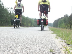
Just as we were leaving this roadside attraction, we saw a bicyclist coming from the opposite direction. This turned out to be Michael Wong, from Atlanta! He grew up in Snellville, went to GSU as an art student and now lives in Decatur. He is riding across the country in support of the project he founded, Bikes for Indonesia. The URL is www.bikes4indo.com. He had spent some time in that region in the relief effort following the Boxing Day Tsunami of 2004, and saw that the basic mode of transportation, the bicycle, needed help, and realized he could bring some of his expertise to bear on it. So, take a look at the site; if you know anyone with a spare bike, or if the local pawnshop has too many to store, put them in touch.
On we went, up to Lolo Hot Springs, where we stopped for lunch. I suppose I was expecting more; the name Lolo Hot Springs seems to connote such luxury and opulence, that coming up on the decidedly downscale collection of buildings was a bit of a disapointment. We elected to go on, since it was only 7 miles to the top and then 13 miles down.
True to form, the last 4 miles to the top were the hardest, but waiting for us at the top was the Idaho state border and a bonus hour, since we would enter the Pacific Time Zone there.
At the top, we realized that we were now irrevocably on the Pacific side of the country. It was fun to dance across the line, back and forth, gaining and then losing the hour, and then finally regaining it for good. But at the top, over 5000 feet, it was cold, and the upcoming descent was likely to exacerbate that coldness, so we put on layers (and I put on my gloves). We didn't think it would rain, despite the thunder we could hear, but we put on our new Patagonia rain jackets anyway.
Of course, the sprinkling started almost the moment we lost sight of the pass behind us. It was light, though, so we were able to enjoy the long, 5-mile, 6% grade, doubly so because not a single vehicle came up behind us until we passed the bottom of the grade and it lessened to a more gradual slope. All the way down, we enjoyed spectacular views, as far as we could see anyway. The mountains rose up on both sides at angles not typically seen in nature.
Speaking of views, I should note that we had ridden through spectacular landscape all day--beautiful forests, (great pine scent), and the Lolo River on the Montana side; the Selway-Bitterroot Wilderness on the Idaho side, the Crooked Fork and Lochsa Rivers running beside the road on the way down; and in the riverbed, lots of rocks, rounded by time and water.
At 5 miles from Powell Junction, the rain started in earnest. Neither Nancy nor I had not put on our helmet covers, so before long our heads were drenched; Nancy had also neglected to put on her amfib pants, so her legs got soaked, too.
The rain continued until we reached Lochsa Lodge at Powell Juntion, where we got their last room--a cute little log cabin of a place with an orange shower. At least it had a shower and toilet; some of the cabins are "rustic" - meaning the showers are over there near the convenience store and the outhouse is a little closer. We tried the TV provided in the room; it got channel 4 and channel 6 (really fuzzy, though), and that was it. Neither one was the Weather Channel, so we did without.
The bonus hour gave us time to clean up before heading over to the main lodge for dinner. For a place out in the middle of nowhere, it was surprisingly crowded; many of the people there had been coming for many years. The lodge dates to 1929, but the original burned down in 2001; the place that exists now is a replacement, and no less an oasis in the wilderness than the original. Walking the short distance to the main lodge, we met three guys there for the weekend fishing, including one who had lived in Portland for 7 years; he knew where we were going to live when we described it. We chatted with them briefly before going in.
When we had arrived, while I was taking care of the registration, Nancy met a man in the restaurant who is cycling with his wife from Lewiston to Whitefish; they live in Portland. We made arrangements to talk later, over breakfast, since they were just finishing dinner. Then, at dinner, we sat next to two guys, one from Beaverton, one from Ashland, who were there fishing for the weekend as well. It came out during the conversation (when we revealed our ultimate destination) that they watch football together in Lincoln City during the one weekend in the playoffs when there are two games on Saturday and two more games on Sunday. I couldn't tell where the cabin was that they rent, but it sounded like it was in the Oceanlake area, near the northern end of town.
After dinner, while perusing some books in the lodge library, we met 8 women from Spokane playing Spite & Malice (a card game that looks remarkably like a game Nancy and I play called Dumb Dora). They call themselves the Spokane Bridge Club, but they said if we are ever in Spokane all we have to do is ask for the "crazy bridge ladies" and anyone can tell us where they are. They get together to play cards when it's dark, but during the day they go out HIKING. Did I mention that these women are in their 60's? They were out hiking in this area today, rugged area I don't think I'D go hiking in. I like these chicks.
Afterwards, in our room, we looked at what lay ahead. One of the options available for us once we reach Kamiah (pronounced KA-me-eye) is known as the River Option, which avoids the nearly 2500-foot ascent to a plateau and the cities of Craigmont and Winchester. However, the map notes that the River Option, following the Clearwater River all the way to Lewiston, is not recommended by the ACA, local cyclists OR the Idaho DOT due to heavy comercial traffic, winding roads, and limited shoulders. We are thinking that if we can get to Kamiah by Saturday night, we stand a good chance of being able to take the River Option on Sunday, thus avoiding a lot of the commercial traffic. We decided to try for Kamiah, a distance of over 96 miles, for that reason. We have some bailout points in mind just in case, but that's the goal. We'll see!
No comments:
Post a Comment