Thursday, July 6, 2006. Avery, OH, to Bowling Green, OH. It dawned on me that we had stayed in a town with the same name as one of our nieces only after we had left; now I wonder how many other such places we have been through. I'll have to check.
We had not ridden even a mile when we encountered Joe, a cyclist from Huron out for a spin on such a nice day. He turned around and rode with us for several miles chatting. He had ridden many of the rides around the area and knew pretty much where we were heading. He had ridden in the Hilly Hundred in Indiana (anyone who remembers Terry Hannigan making the trip up to Indiana from Lawrenceville knows what I'm talking about); Joe allayed my fears about the "hilliness" of the Hilly Hundred, and that it was down in Bloomington, south of Indianapolis, not part of our route. Poor Joe probably struggled to ride as slow as we were going (just about 14 mph - he looked like he could ride about double that), but was very friendly and fun to talk with.
The first thing we noticed about the terrain away from the lake is that it is relatively flatter. We passed farms, mostly; corn and winter wheat, at first, and then a crop we could not immediately identify, thinking it was too recently planted for us to be able to tell what it was. Turns out those crops were radishes, a large part of the agriculture in this area. The corn is not high as an elephant's eye yet; maybe as high as an elephant's thigh.
You may recall that Ohio had recently experienced some heavy rainfall; in fact, six northern Ohio counties were included in a federal disaster area declaration, and we were riding through three of them. So when we came to a turn where part of the road was blocked with a "Road Closed" sign, I momentarily imagined the road either washed out, or partially covered with water. But since we are in the habit of ignoring such signs while on this trip, we rode on by. You know how on a hot day, on a long flat road, you can see the mirage of water ahead? Shimmering low on the horizon, you can imagine a river running across the road ahead, until you approach and the image dissipates. Well, that's what it seemed like on this road, except as we approached the "mirage", it did not dissipate; there was actually a large stretch of water across the roadway. Impassable. We had to turn around and go back, marking the first time we have had to do that after bypassing a "Road Closed" sign.
Fortunately, the farm roads in this area are gridlike, so it was a fairly simple detour to get around the locally flooded area. We reached a point where we could turn right to rejoin the route, or continue straight to another right turn to rejoin the route, we continued straight, only to find the turn ahead was onto a gravel road. We ended up going on a more heavily traveled route for a short distance before reaching our route. It's nice not to be afraid of detours anymore.
Part of today's ride included the North Coast Inland Trail, a 9-mile paved path into Fremont. We missed the turn at first but found it after that, and rode happily along (despite the numerous stop signs as we crossed roadways). At one point, we found ourselves behind a pair of cyclists (one on a recumbent, the other on a cruiser), and struck up a conversation as we went along. Bruce and Larry were just out for a trail ride, out and back, about 15 miles. They have summer places nearby, but Bruce works in the DC area and flies here occasionally (the route from BWI to Cleveland is not pricey). Bruce told me that his wife stays here all summer while he comes up for a week at a time every so often. I didn't ask what kind of job allows for that kind of flexibility, but maybe I should have!
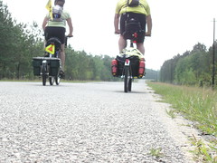
We rode along with Bruce and Larry for several miles, until we reached the point where they had started; we accompanied them to the trailhead so we could give them the website, and also ask for a good place for lunch in Fremont (we were approaching 30 miles since breakfast). As we stood there talking, and that question came up, another cyclist sitting nearby (waiting for a friend) spoke up with two recommendations. John Madden (no relation to the coach) told us about Chud's, which was near enough to our route that we decided to go there. Before we left, we got a picture of Bruce and Larry for the blog (and which Nancy has probably already posted as of this writing). Very friendly couple of guys; thanks for riding with us!
After a good lunch at Chud's, we headed off through more corn and winter wheat and radishes, with hardly a car passing us all the way until we reached Pemberton Road. On that road, several interesting and unique vehicles passed us, including a vintage fire engine and a 1941 International pickup truck, all in surprisingly good condition. Upon reaching Pemberton, it became clear what was going on - it was Cruising Night in Pemberton, and as we rode slowly through town we passed dozens of beautiful, clean vintage cars (lots of Corvettes and not a few original Thunderbirds) all parked along the downtown roadway. To top it off, just as we left town, I saw a 1963 Corvette Convertible rolling in. Nice. But, with gas (here, at least) at $3.02 a gallon for regular, I felt pretty smug pedaling by all those relative gas guzzlers.
After we left Pemberton, we saw the first evidence of winter wheat harvest, as we expected to see around this time. A lone harvester had just begun to take in his field on our left as we rode along Poe Road on our way into Bowling Green.
Upon reaching Bowling Green, we rolled in to a place that looked nice, but did not decide to stay there until we went in and asked if their TV channels included OLN, the Outdoor Life Network, which broadcasts coverage from the Tour de France. They DID! So we got a room. We also availed ourselves of the pool and hot tub, which is just gravy.
And, for the first time, we got to watch the OLN Prime Time coverage of the Tour. It was nice to get a fix.
This morning we will head to the post office and then on to Defiance, OH. The eagle-eyed will take note that we are now nominally back to our intended route, stops and all; our expected arrival in Pueblo is now around August 5, which I will confirm again after reviewing the maps when we stop tonight. We may go see the Pirates of the Carribean movie tonight as well, depending on the crowds.
Today we will also cross two important milestones: we will pass 3000 miles, and we will finally pass the line of longitude along which Lawrenceville, GA, is located, where we started. Today we will finally be west of our starting point. That will happen somewhere after Grand Rapids but before Napoleon.
OH, one last thing - can someone confirm when we will enter the Central Time Zone? My maps say it is at the line between White and Jasper counties in Indiana, but the phone book says that Indiana is ALL on Central Time during the summer. I know we will find out soon enough, but I'd like some independent confirmation. Thanks!
3 comments:
Indiana is so very confused on time zones, trust me I went to Purdue (West Lafayette, IN). They just changed some counties to Central Time zone, but not all of them. Try this site, or let me know the counties you plan to travel and we can look them up for you:
http://www.timetemperature.com/tzus/current_time_in_indiana.shtml
Tim
Here is some more info:
Effective April 2, 2006
All of Indiana will observe daylight saving time.
Effective April 2, 2006
The eight Indiana counties of Daviess, Dubois, Knox, Martin, Perry, Pike, Pulaski and Starke will move from the Eastern to Central Time Zones.
Those above are in addition to "the Region", counties near Chicago.
From infoplease.com:
Until April 2005, when Indiana passed a law agreeing to observe daylight saving time, the Hoosier state had its own unique and complex time system. Not only is the state split between two time zones, but until recently, only some parts of the state observed daylight saving time while the majority did not.
Under the old system, 77 of the state's 92 counties were in the Eastern Time Zone but did not change to daylight time in April. Instead they remained on standard time all year. That is, except for two counties near Cincinnati, Ohio, and Louisville, Ky., which did use daylight time.
But the counties in the northwest corner of the state (near Chicago) and the southwestern tip (near Evansville), which are in the Central Time Zone, used both standard and daylight time.
The battle between the old system and DST was contentious and hard-won—bills proposing DST had failed more than two dozen times until finally squeaking through the state legislature in April 2005. As of April 2, 2006, the entire state of Indiana joined 48 other states in observing Daylight Saving Time. But it wasn't quite as simple and straightforward as all that—telling time in Indiana remains something of a bewildering experience: eighteen counties now observed Central Daylight Time and the remaining 74 counties of Indiana observe Eastern Daylight Time.
Good luck.
Dad
Post a Comment