Sunday, April 30, 2006
Homemade Maps to TripTicks
Thursday, April 28.
We decided late laast night thta we would have to go on past Garnett and Robertville, and go all the way to Point South, SC, to a KOA Kampground there since the weather was supposed to be cool and theere were no identifiable places to stay short of Point South. It would mean about 70 miles instead of only 43, but there were flat miles and with the cool temps we figured we could do it. A call to the kampground confirmed that there would be room for us.
We headed on down the Savannah Highway, finding short stretches like yesterday's where we could ride on a paved, but not yet open,length of highway. Some of the roads had no shoulders, but traffic was pretty light; gsto\d onbridge andd got a picture near some emerl green water in a pond of some kind.
Things Seen By the Side of the Road Update:
A String of Green Beads
Two John Deere tractor mailboxes
One John Deere Road sign
Once odd, but now seen in such abundance that they are now commonplace: Turkey Vultures! And no, there are not following us.
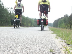
We knew we would leave my makeshift route today and pick up the Adventure Cycling (www.adventurecycling.org) Atlantic Coast Route, but the moment it came was almost anticlimactic. Nancy was behind me and had just called out "Truck Back" to warn me of a truck coming up behind us. I couuld see a truck coming from the opposite direction. We were already hugging the meager shoulder, but up ahead I could see a crossroads where we could pull out, and as we drew closer I could see that it was the one we were looking for. We needed to go left but prudently pulled off to the right to allow the trucks to pass before crossing over to Clyo-Kildare Road, making our entry onto the Adventure Cycling maps we have for so long anticipated following. For a little while, we rode in awe that we had come so far in just 6 days. We got a turtle to take our picture--we'll upload it soon.
Subscribe to:
Post Comments (Atom)
No comments:
Post a Comment