Wednesday, September 27, 2006

Stats, Part 1

From Lincoln City, OR.
 
We thought some of you might be interested in some of the statistics of the journey -- miles, days, and so on. So, here is a start:
Total miles ridden: 6607.7
Number of days ridden: 134
Rest days: 22
Average miles/day: 49.3
Longest day, in miles: 96.45 (Powell Junction, ID, to Kamiah, ID)
Longest Day, in time: 7 hours, 42 minutes, 37 seconds (Lander, WY, to Dubois, WY)
 
Fastest Average Speed, one day: 14 mph (Powell Junction to Kamiah)
Slowest Average Speed, one day: 6 mph (Canon City, CO, to Guffey, CO)
Highest Plausible Speed achieved: 51.1 mph (Matthew, on the descent from Hoosier Pass)
Highest Speed recorded (not plausible): 86 mph
 
Milestone Points:
1000 miles: near a field in Virginia
2000 miles: at the entrance to the Lake Champlain Islands, Vermont
3000 miles: on a country road outside Bowling Green, OH
4000 miles: on the ONE stretch of road we had a tailwind in Kansas, north of El Dorado
5000 miles: nearing Lander, WY, with the Fab Four
6000 miles: entering Lewiston, ID
 
More soon!

Warm Showers Visitors


Warm Showers Visitors
Originally uploaded by nstovall8.
These three cyclists--Chris, Matthias and Tobias--are riding the Coast route

from Germany. Chris and Tobias are touring for just a few weeks; Matthias

is on a 3-year tour from Patagonia to Alaska. They found Suzi & Jim's house

on the cyclists' warm showers website, and we enjoyed talking with them and

seeing Matthias' pictures from Bolivia. More cyclists are due at the house

tonight!

Roads End


Roads End
Originally uploaded by nstovall8.
From the top of this rise, it's all downhill to the literal Roads End for

us.

The End is Near


The End is Near
Originally uploaded by nstovall8.
At an overlook by the ocean, a friendly tourist snapped this shot of us on

our last day of the Scenic DeTour.

Princess Of Wales


Princess Of Wales
Originally uploaded by nstovall8.
Megan was dubbed "The Princess of Wales" by her fellow cyclists. We met her

on one of the last days of her trip as well as ours. She'd ridden from

Yorktown, VA to Florence, OR, and was heading up the coast to Astoria.

Cape Mears


Cape Mears
Originally uploaded by nstovall8.
The lighthouse on Cape Mears sits at about sea level, though the road to the

park is uphill . . . both ways.

The Saga of Bay Ocean


The Saga of Bay Ocean
Originally uploaded by nstovall8.
This marker tells the sad tale of Bay Ocean. No amount of engineering could

save the doomed development.

Dolly


Dolly
Originally uploaded by nstovall8.
At our stop in Tillamook at the Blue Heron Cheese Company, Matthew visits

with Dolly the Llama.

Hug Point


Hug Point
Originally uploaded by nstovall8.
This spot was named Hug Point not for its' romantic scenery, but because it

was so narrow that cars were forced to hug the road to keep from falling of

the cliff and into the ocean.

The Ocean


The Ocean
Originally uploaded by nstovall8.
Another beautiful day, riding along the oceanfront.

Fort Clatsop


Fort Clatsop
Originally uploaded by nstovall8.
Heading down the coast, we stopped in at Fort Clatsop, the site where the

Discovery Corps spent the winter. It rained on them 112 days out of 116; we

had beautiful weather. A beautiful spot for a park---or a fort

My New Favorite Store


My New Favorite Store
Originally uploaded by nstovall8.
The Rain Store in Astoria has everything for a rainy day. They also have a

website: www.umbrellastand.com

Family Dinner


Family Dinner
Originally uploaded by nstovall8.
While in Portland, we had dinner with Matthew's parents, Suzi & Jim, and

Matthew's twin sister Kim, her husband Ron, and their sons Garrett (who's 16

now) and Tanner. Our waitress was some kind of alien; she never wrote down

a thing, remembered every minute aspect of our orders, and didn't feel the

need to number us.

Tuesday, September 26, 2006

Road's End

Monday, September 25.  Pacific City, OR to Lincoln City (Road's End), OR.
 
Due to the dog days of summer, and the Inn's policy about not installing a/c units, we spent a fairly uncomfortable final night on the road.  It wasn't too hard to get up early, get breakfast, and get on the road one last time.
 
We had about 20 miles to ride before reaching Otis, where we planned to meet Jim & Suzi for lunch at the Otis Cafe.  We continued on the Scenic Cape Route via Hwy 101 through the small burg of Pacific City, the bump in the road known as Oretown, and then into Neskowin,  where we turned onto Slab Creek Road and the Old Scenic Highway 101.  This route avoids the massive climb at Cascade Head, but is also a stunningly gorgeous meander into a primordial rain forest setting.  Towering trees surround the road, scenting the air with cedar.  Beneath them, glorious ferns carpet the ground.  Everything is so lush and fertile here, that even cracks in the road surface are filled with bright green moss.  We begin our ascent in the shade, but soon the effort of climbing warms us up and we stop to take off our jackets. 
 
The climb continues for a long time, but the grade is fairly gentle.  The road twists and turns; we pass the Neskowin Valley School and hear the happy shrieks of children out for recess in the schoolyard.  We pass mile markers, but have no good idea how many miles we'll climb before reaching the 600+ feet to the summit.  Finally, I call for a break, and we decide to stop just at the next turn.  We haven't seen more than 3 or four cars since we turned onto Slab Creek Road, but as we're stopped we can hear a car approaching from the curve just beyond.  Matthew says "I wonder if that's my dad", and as the car comes around the bend we can see that it is, indeed, both his mom and dad.
 
Hugs all around, then a few pictures (I think I know now how Lewis and Clark felt when the Indian tribes welcomed them into their villages).  We had made it to the crest of the mountain, Jim assures us, and it's a downhill ride from here to the Otis Cafe.  Jim & Suzi agree to follow us, so we can take the lane and not have to worry about cars passing us on the descent.  My odometer reads 6597.9 as I start the descent, and I don't turn my pedals for the next 3 miles.  It's about 5 miles total to the Otis Cafe, and we cover that distance in no time.
 
For anyone who's never been, the Otis Cafe is worth the stop in Otis.  It's one of maybe 4 businesses in the entire town, which was sidelined when Hwy 101 was "straightened".  It's one of our favorite places in the area, famous for their homemade breads and pies as well as for their German hashbrowns.  We had to wait a while for a table--there are only 6 tables in the entire cafe--and that gave us a chance to come to terms with the fact that we were about 5 miles from Jim & Suzi's home on the beach in Roads' End.  We left the cafe with a loaf of bread and a berry pie.
 
And then came the last 5 miles.  We rode along the wide shoulder of SR 18 for a short while, and then were back on Hwy 101 for another mile or two.  We took a right turn onto Logan Road, and made the short climb to the turn onto Roads' End.  From the top of that hill, we had a clear view of the ocean and knew that it was, literally, all downhill from here.  The Stovall B&B was about a half-mile away; the ocean just beyond their hot tub.  We flew down the hill and were met in the driveway by our gracious hosts and Honey, their Malamut mix.  We unloaded our trailers, and rolled down to the beach for the ceremonial wheel-dipping ceremony, which marked the official end of our trip.  Within 30 minutes, we were lounging in the hot tub, a glass of Merriweather Champagne in hand, toasting six thousand, six hundred miles.
 
The journey ended the way it began--among family.  No press, no fireworks.  We talked last night about some trip highlights--the Columbia Gorge, the high deserts in Wyoming, the descent from Lolo Pass, Cedar Point Amusement Park, the Great Dismal Swamp are just a few of the fabulous sights we've seen on this trek.  And seeing them from the seat of a bicycle is an experience totally different from touring any other way.  Neither of us feel like Superman (or Wonder Woman), but we also don't feel like we couldn't have gone one more mile.  I was intimidated by the Rockies, but now I see that they're just one more day of riding.  As the saying goes, "Adversity becomes adventure after a shower and a couple of beers".  
 
We'll be hanging out here at the beach for a few weeks while we collect ourselves and our things, then begin to make ourselves at home in our new home in Portland.  Hockey season starts soon, and while Portland doesn't have an NHL team, but we hope that friends and family will visit us here anyway.  Happy Trails!
 

Monday, September 25, 2006

I Looooove Capes!

Sunday, September 24. Tillamook, OR to Pacific City, OR.

We didn't even put our wheels to the road until 11am this morning, since our ride today would be less than 40 miles. Sunday morning breakfast at the Pancake House was just too inviting; we lingered over coffee and the Sunday Oregonian until the breakfast crowds were long gone.

We chose to take the Three Capes Scenic Route today, and almost immediately found ourselves in the middle of Tillamook's dairyland. These cows are famous--they're the backbone of the Tillamook Dairy cheeses, milk and ice cream. Jersey cows are the overwhelming favorite here, with good reason. Their milk has a much higher buttterfat content than their higher-profile cousins, the Holsteins, and produces better flavored cheese and ice cream.

Just before the Cape Mears State Park is a marker for the lost city of Bay Ocean. In the early 1900's, a Kansas developer came to the Bayocean Peninsula with dreams of creating another Atlantic City (Pacific City, presumably). Several town buildings were erected, residents moved into town, but when a winter storm eroded the foundation of the town's swimming pool, confidence in the foundation of the town itself began to erode. By the 1960's the entire town was washed away.

Even though we're within spitting distance of the ocean, the route begins to climb away from the shore and up into the Coast Range. The peaks of this range are considerably smaller than the Cascades or the Rockies, but the roads here are graded more steeply. As we climbed, I found myself peddaling along in my granny gear, wishing for an even grannier gear. Once we got to the top of the climb at Cape Mears, we descended into the Cape Mears Park to have a look at the Mears Lighthouse and the Octopus Tree (a really old, really huge Sitka Spruce). We'd both been here on a previous trip to the coast, but it seemed like a worthwhile side trip. Just as we were about halfway up the lighthouse staircase, Matthew remembered that he'd left his Camelback at the top of the hill, near the park entrance. We cut short our visit to the park, and were about to make the climb back up the hill when a woman approached Matthew and asked if he'd lost his Camelback. They had seen us come in, and on their way out of the park had noticed the pack. They picked it up and brought it down to the parking area to search for us. "See, there are nice people in the world" was their comment as they handed the pack back to Matthew. If they only knew!

Back on the road, we descended out of the Coast Range and headed to Oceanside and Netarts. Riding along Netarts Bay is beautiful. A picturesque body of water on one side of the road, a rocky mountain on the other. The route along the bay turned back toward the mountains, and we climbed back up over 800 feet to the Cape Lookout State Park. For anyone who's considering this route, I offer the following information. The roads along this part of the route have no shoulders to speak of, although there is a bike lane on the southbound side of the climb up to Cape Lookout State Park. We are riding in the off season, so traffic was generally light and well-behaved. The road surface itself is patchy, and the dappled, shaded sunlight made it difficult to tell where the rough spots were. If you were to add either bad weather or heavy traffic to this mix, I'm not sure you'd have a very enjoyable ride.

Anyway, the climb to Cape Lookout is about 2 miles of climbing, and fortunately for us, we had the bike lane on our side. As we came down the descent, I was surprised to see that the landscape changed from majestic forests to open sand dunes. It was as though we'd been plucked out of Narnia and spit out into the sands of Arabia. And that's when we met the Princess of Wales.

Megan, who is actually from Wales, was making her way up toward Cape Lookout as we descended. I crossed over to her side of the road, astonished that we'd run into at least one more cross-country cyclist. Megan began her journey from Yorktown, VA about the same time that we left Lawrenceville, and she'd made it to Florence, OR, just a few days ago. Her plan is to finish riding in Astoria, then ship her bike back to the UK before heading down to LA for a "proper holiday". She'd thought about touring the US with an RV, but decided she didn't want to spend months watching the road. So she put up her house for rent, quit her job, and found her way to Virginia. She'd only ridden about 200 miles with her bike "Jimmy" before deciding that this was something that she could do. I asked her what she was returning to in October and she replied, "the house is let until June, and of course it's winter in England but summer in New Zealand". That's the spirit! We wished her good luck and continued down the mountain to Pacific City.

The last few miles of the day's trip was on Whiskey Creek Road, a road which is more of the same shoulderless patch job that we'd ridden earlier in the day. Because the road also has a lot of twists and turns, the posted speed limits are 25-35mph. And even though we were having to hunt and peck our way around potholes and patches, the majority of the traffic was patient with us and waited for oncoming traffic to pass them before they passed us. Except for one. There's always one. And this one was a big RV, who honked at me (since I was riding sweep) before angrily passing. Matthew stopped short and turned back around to see what the commotion was all about, and when the RV passed us and we could see a cluster of bicycles clamped on to the back of the vehicle, he lost it. A blue streak came spewing from his mouth as he churned his pedals to catch up with the behemouth. The RV hanked at us again and lumbered out of my view, although Matthew did chase him for a little while longer.

It was just a few more miles to Pacific City, where our accommodations at Cape Kiwandah are a good prep for staying in the Princess room at the Stovall B&B in Lincoln City.

Down pillows? Check. Feathertop bed? Check DVD player? Check. Ocean view? Yes, but only from the balcony. At the B&B, even the bathroom has spectacular ocean views. And here at Cape Kiwanda, the rock feature just off shore is known as "Haystack Rock". Funny, that's what the rock feature at Cannon Beach was called, too. But that one has little rocks all around it called "The Needles". Cape Kiwanda's rock doesn't have any needles. Cape Kiwanda's rock needs a new marketing director.

We crossed the street and headed to the Pelican Pub for dinner. The Pub also houses a microbrewery, apparently good enough to win medals at several beer contests. Matthew sample the Doryman's Dark Ale and pronounced it "pretty good". Also "pretty good" was tonight's sunset, dipping into the ocean and painting the sky with a thin orange line at the horizon.

Tomorrow is our final day of riding, and we'll end our trip (appropriately enough) at Road's End, where the Stovall B&B is located. I guess tomorrow's blog will be coming to you from the hot tub. Check. On the beach. Check.

Sunday, September 24, 2006

We Brake for Ice Cream

Saturday, September 23. Cannon Beach, OR, to Tillamook, OR.

We left the window open all night; we could just barely hear the surf, which was nice. Maybe too nice - we almost overslept, and finally got on the road around 10, after going over to Mo's for breakfast (who knew?). It was warm enough that tights were not necessary, which hasn't been true for many, many days now; and we even shed our jackets soon after the first descent.

As might be expected, todays route was replete with incredible views at the several overlooks along the way. And, as might be expected, getting to those overlooks involves climbing a good bit - and the profile shows some utterly dramatic climbs. Of course, that meant that those climbs were not as bad as they were depicted. True.

We arrived at Hug Point State Park, and had to get a picture in front of the sign there (yes, we were hugging); but we didn't venture down to the parking area. Too steep.

We passed through one more tunnel equipped with a button-activated light warning system, just past Arch Cape. Even with the lights flashing (I presume they were still flashing), cars entered the tunnel at speeds that made me worry. Of course, we made it, but being passed by a semi and then an RV INSIDE A TUNNEL is a harrowing experience.

We are ocean-side of the Coast Range mountains here; the slopes are lush, green, and subject to slides. We came across several places along the roadway that showed evidence of those slides - new asphalt in half-moon shapes abutting the downslope side. It's not hard to imagine that driving on this road would require more attention than usual after heavy rain. Fortunately, it's been dry a day or two now, so we didn't have much to worry about in that respect.

Oh, and we had a TAILWIND all day. And clear skies, too; and it was warm without being just BAKING. We struggled to recall a day so perfect for riding in the direction we were going (we've had days that would otherwise have been perfect but for the heat, the ferocious head- or crosswind, or the rain). We fairly sailed through the towns of Manzanita, Nehalem & Mohler before entering the lush Foley Creek valley. A more direct route to Bay City than 101, and probably safer, by all accounts, the road followed along Foley Creek (a tributary to the Nehalem River) up to a shallow pass before descending the other side along the Miami River. We kept waiting for the awful climb depicted on the profile, but never reached anything so bad.

Bay City has places to eat, and we expected to have lunch there; but we rode through without finding a suitable lunch spot, and before we knew it, we were just 5 miles from Tillamook. So, because we needed a break, we stopped roadside and had a snack on the southern outskirts of Bay City, not quite within sight of Tillamook Bay.

Lunch, we decided, would be at the Blue Heron in Tillamook. It was one place where we could get sandwiches made with Tillamook cheddar and finish with a scoop of Tillamook ice cream. It is also at the Blue Heron that you can can meet Dolly the Llama, and when you have that brush with greatness, you can feed her an apparently yummy mix of oats and stuff. The goats will also clamor for some, but they aren't nearly as enlightened.

After lunch, we stopped for an extra tube for my trailer at a sporting goods store. I have found my trailer tire flat twice in recent weeks but have yet to find a leak; so we picked up a replacement tube for the next time it happens, if it happens, in the next two days.

The Marclair Inn, our stop for the night, is centrally located in downtown Tillamook (I just like saying Tillamook). We were able to take a quick walking tour of about 6 downtown blocks, scoping out a spot for breakfast tomorrow, before heading back for dinner at McClaskey's, the restaurant attached to the motel; it was the best available option from among a surprising number of them.

Tomorrow we will embark on the Three Capes Scenic Route, visiting Cape Meares, Cape Lookout, and Cape Kiwanda, before stopping at Pacific City for the night. From there, it will be a 20-mile ride on Monday to the Otis Cafe for lunch, and then a 6-mile, all-smiles ride to the finish. The weather is supposed to hold like it has been, which we could not have even hoped for.

Sure, we could probably make it all the way to Lincoln City tomorrow, but we want to arrive on Monday so my Dad can be there to have lunch with us and help us celebrate reaching the Roads End, both figuratively and literally. Since he will be working late Sunday, we'll wait for Monday when he will be home. Just two days left!

Saturday, September 23, 2006

The Pacific Ocean, at last

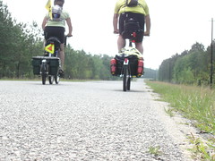
Friday, September 22. Astoria, OR, to Cannon Beach, OR.

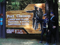
Let's get this straight: we are not really slacking here, even though we only covered about 31 miles today. We stopped at Fort Clatsop on our way out of Astoria to get one last, surreal taste of the Lewis and Clark story. That took time.

We almost made a special trip yesterday to Fort Clatsop, but didn't because it was on the route we would take today; in retrospect, we made a good decision. Fort Clatsop, for those unfamiliar with the story, was the winter camp for the Corps of Discovery in 1805 before they headed back to St. Louis. It was also one of the rainiest winters on record, with just 4 rain-free days in the 116 they were there.

This Fort Clatsop is a relatively new addition to the array of Lewis and Clark-related spots along their route; in fact, the fort itself is still under construction. Furthermore, the location of the fort itself is not really known, and the fort under construction seems located more for its proximity to the visitor's center than for any relation to historical accuracy.

There's more: the visitor's center is filled with exhibits and some good information about the expedition, but not very much about the role of the winter camp itself. There is a short film, about 20 minutes, which we thought might portray some more details about the expeditions' winter; but it did not. In a surreal kind of retelling, it instead portrayed a native american woman telling the story of the expeditions' arrival at the coast to a group of children as they all sat around a campfire on the beach - in 1841. It's hard to understand the choice of 1841 as the setting for the film, since that year doesn't represent any particular turning point or even significant event. But even more confusing was the fact that the story she told was only SORT OF about the expeditions time at the coast; mostly it was about the little conflicts they had with the native population there, and there were some sequences that seemed like modern ideas were anachronistically placed in her descriptions. Overall, it was less elucidating and more confusing than I hoped.

The fort, still under construction, is not open for close inspection; instead, you can only get close to the outside, looking in to the courtyard. It will be a nice fort when it is done, probably pretty close to the original.

We decided to move on, considering the unfinished state of the whole exhibit; perhaps we will return another time, now that we will be living relatively close by.

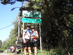
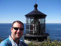
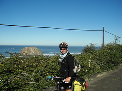
The day brightened, literally; the morning's cloud cover dissipated and left clear skies for the remainder of the days' ride. The road to Seaside is actually called Lewis and Clark Road; it follows (what else?) the Lewis and Clark River before climbing a small (600-foot) rise just a few miles outside of town. On the descent, we caught our first real glimpse of the Pacific Ocean; and, riding down 12th Avenue straight towards the ocean, we finally heard the surf about a block from the pedestrian walkway known as the Prom. And then, there we were, within sight of the surf. We stopped and got a picture, and of course we laughed as we both said "Ocean in View! O the Joy!".

After lunch, we got dessert at the Portland Fudge store on Broadway; Tsunami Bark, which is milk chocolate with rice crispies, marshmallows, peanut butter and chocolate chips. Mmmm.

By the way, who else is surprised by the fact that the entire town of Seaside is in a Tsunami Hazard Zone? The view from the oceanfront homes is not exactly great; from ground level all you can see is the vegetation on the dunes and a little of the sea beyond. Nothing dramatic. And, if -- no, WHEN that tsunami comes, Seaside will be under water. I was a little relieved as we climed the hill out of town and passed the sign announcing that we were leaving the tsunami hazard zone.

I thought it would be about 10 miles to Cannon Beach, but it turned out to be just 7. We rolled past, heading to Tolovana Park, a southern suburb of Cannon Beach, where we checked in to the Tolovana Inn. Our room is one of the few that do NOT have an ocean view; instead, it has what they call a "mountain view", a nice way of saying it faces the opposite direction from the ocean.

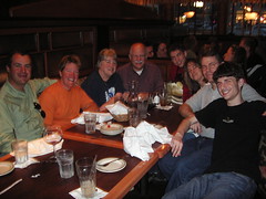
We passed the afternoon talking with Nancy's sister Emily (on the phone), who was supposed to undergo surgery today; so imagine our surprise when she answered her phone. Long story short: other, emergency surgeries (on other people, of course) pushed her scheduled procedure back far enough that it had to be canceled. We just wanted her to know we support her; it took us more than two hours to say that, and a whole lot more.

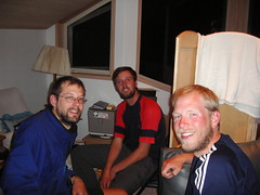
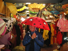
We had dinner at Mo's, just in time to watch a nice, ordinary sunset (which I'll take, if it means more nice weather). This Mo's is apparently the original one; there is a Mo's down in Lincoln City, too, just north of Siletz Bay (I think - you locals can correct me Monday when we get there). As a bonus, we got a tiara after dinner - picture soon. Nancy says it is a general purpose tiara, for any occasion, like when your regular tiara is out at the cleaners.

Tomorrow, we head to Tillamook, and more importantly to the Tillamook Dairy, where we will be able to get Tillamook Ice Cream. The Blue Heron Cheese Factory is also there (in Tillamook County there are more cows than people). Perhaps not surprisingly, one other notable institution there is the Tillamook Beef Smoker, producers of some of the best beef jerky available. One thing is certain: we won't starve in Tillamook. Three days left!

Friday, September 22, 2006

Discovering Astoria

Thursday, September 21. Rest day in Astoria.

Even though we'd just had a rest day in Portland, we had planned to take a day off in Astoria to explore this coast city. Besides, the weather hadn't quite cleared up this morning, but the forecast for the weekend looks great.

So after a continental breakfast at the hotel, we unhitched our trailers, jumped on our bikes, and headed off toward downtown Astoria. We found the trolley tracks right beyond the hotel, and followed them down to the waterfront. Astoria is a city that began as a trading post for beaver pelts, but once fashions changed, lumber and salmon became the town's key industries. Immigrants from around the world came to be part of this boomtown, and their influences can still be seen throughout the city. In particular, there is a strong Finn influence here, celebrated every year with a Suomi Festival (held in July; we missed that one, too).

Our first stop on the waterfront was the Maritime Museum. This building is dedicated to all things nautical when it comes to the Columbia River, so everything from a map of lost ships (The Graveyard of the Pacific) to duck decoys are on display here. The river has a wild and woolly history, and still "makes waves" as ships hoist their sails and attempt to cross the sand bar at the mouth of the river.

After the museum we headed to the library, hoping to be able to upload some pictures. But their internet access was down today, as was the case with most of Astoria, so pix will have to wait.

We made a quick stop at Columbia Travel to get lodging info for the next few days, and then dropped into the Hotel Elliott just across the street. A $4 million restoration has turned this former flophouse into a luxury hotel. Maybe on our next visit we'll stay here.

Lunch at the Urban Cafe' was next on the list, including the chocolate hunk cake. These people know how to serve chocolate cake--whipped cream, ice cream (Tillamook Vanilla Bean), and a pitcher of warm chocolate sauce for you to drizzle on as needed. mmmmmmm.

After lunch we spent the rest of the afternoon at a local coffee and book shop, watching the sun poke through as the wind blew the clouds eastward. I'm hoping that trend continues through the rest of the night, and we awake to clear, sunny skies. The dream continues . . .

Thursday, September 21, 2006

Ocean in Sight . . . I Think

Wednesday, September 20. Rainier, OR to Astoria, OR

We made it to the Oregon Coast in true Lewis & Clark style--in the rain.

The skies were misting while we had breakfast, but it seemed as though we would have dry weather when we started out from Rainier this morning. It was a little cold--thank goodness for the 1.5-mile, 600 ft. climb out of Rainier. By the time we got to the viewpoint near the top I was sweating under my layers, and stopped to take off my gloves and rain jacket. Big mistake. As soon as we started the descent, I wanted my gloves back on again. Not to worry--the descent was more of a false flat and we had another hill to climb.

Now that my body temperature had equalized, I was able to enjoy the ride through Alston, Clatskanie (pronounced clat-scan-EYE) and on into Westport, where we planned to stop for lunch. We were still riding on Hwy 30, which has a decent shoulder, but it also has a fair amount of traffic. Each time we passed a "Passing Lane Ahead" sign, we knew we were in for a climb.

As we pulled into Westport we came upon the Oregon Berry Patch, which looked like a nice lunch spot. Turns out that it's much more than that. 30-some years ago, a local man started making berry jams as Christmas gifts, and when demand outstripped production, he and a partner opened the Berry Patch. You can purchase jams, jellies, catsup, mustard and syrups made from huckleberries, blueberries, blackberries, raspberries, choke-cherries and Oregon's own Marionberries. As we sat inside having lunch, the rain started. It would continue for the rest of the day.

Our waitress warned us of a "big hill" outside of town, but we assured her we'd already done the big hill out of Rainier. "This one is just soooo looong" she said, using her face and hands to make the point for us. As we left Westport, (now toting a bottle of blackberry syrup), we did encounter that hill. She wasn't kidding. While the slope of the hill wasn't steep, it was verrrry, verrry long. And now it was raining in earnest. The rain was cold, and when the big drops hit my face, it stung.

We rolled along through the countryside, getting closer and closer to the ocean. The route bent away from the Columbia, and took us past fish hatcheries, logging operations, and a National Forest. It occurred to me that this is just what we saw at the beginning of our trip in South Carolina. Back then, in late April, the summer was just beginning and temps were in the 90's. We wouldn't see rain for a few more weeks. Today, though, the rain didn't bother us. We had jackets and helmet covers that actually repel water, for one thing. But maybe the fact that we are so close to the end made a difference in our demeanor. Or maybe the last 140 days on the road has helped us know that we'd make it to the day's end. The weather is what it is. We were both singing Astoria riding songs in our heads as we rolled along, up one hill after another.

We stopped at John Day Park for a bio-break, and Matthew was able to squeeze water out of his gloves just by making a fist. (Note to self: investigate water-proof gloves for life in the Pacific Northwest) No point in hanging around--we weren't getting any drier.

As we got nearer to Astoria, the road came back parallel to the Columbia River. At one break in the trees, Matthew called out that the ocean was just beyond the river, but the river's edge melted into the grayness of the sky, and the ocean view was obscured by the day's rain.

Just when I had stopped counting miles, minutes and hills, we rounded a corner and entered Astoria. It seemed that the rain intensified and the wind gusts increased just as we arrived. At the "Welcome to Astoria" sign we stopped for our souvenir picture, then continued on through town to our hotel, battling 30+ mile-per-hour winds for the last few miles. We'd made it!

After a celebratory (and complimentary) cookie and glass of OJ in the hotel lobby, we sloshed upstairs to our room and took long, hot showers, then put on warm, dry layers. Now feeling clean and cozy, we hung around the hotel waiting for a break in the weather to allow us to dash out for dinner. We finally called a taxi for the trip into town and had dinner at the Golden Luck restaurant. The weather finally did break during dinner, so we could walk back to the hotel. The winds were still pretty strong, but the cool night air and the short walk felt good.

We'll stay an extra day in Astoria to be able to visit some of the Discovery Corps historic sites such as Fort Clatsop. The Corps spent 116 days in Astoria in 1805, and it rained 112 of those days. We're hoping the weather will clear up by Friday. The coast route can be very hilly, so we plan to take 4 days to cover the distance between Astoria and Lincoln City. I'm even hoping that we'll have a tail wind for one day while we're riding down the coast. It could happen.

Tuesday, September 19, 2006

Rainy Ride to Rainier

Monday, September 18. Portland, OR. Tuesday, September 19, Portland to Rainier, OR.

After spending a rest day on Monday in Portland, we were nearly ready to get on the road again. Matthew's parents, Suzi and Jim, drove up from the coast on Monday to spend the day with us, and we enjoyed a preview of our new home-city. Lunch at the 99-year-old Oyster Bar, a walk through the city's Rose Garden, a quick trip to both REI and Trader Joe's, then dinner with Matthew's twin sister and her family in Beaverton filled the day. It will be another adventure for me to figure out how to get around the city.

After a leisurely breakfast on Tuesday morning, we headed out. While we ate, the rain seemed to clear out, but minor showers misted over us for most of the morning. We rode on Willamette Blvd., taking a cycle-tour of Portland's northwest neighborhood around Ainsworth & Vancouver streets. Crossing the Willamette River via the historic St. Johns Bridge put us on the outskirts of Portland, and soon we were in Linnton. At a c-store stop, we met Scott Kelly, a local cyclist from nearby St. Helens. He recommended Ichabods Restaurant as a good lunch stop in Scappoose, about 12 miles from Linnton. We did stop and have lunch there, and as we were leaving we ran into Scott again. He wanted to give us a contact e-mail so we can hook up and go cycling together once we get settled in town.

From Scappoose it's only about 8 miles to St. Helens,and then another 18 miles to Rainier, where we'll stop for the day. We're still on the Lewis and Clark Trail, which means that the Columbia River is our constant companion. As we rode out of Portland, the river was close, calm and decidedly urban. Houseboats lined the docks and piers that are just a stone's throw from the bicycle path.

Once we get out of Portland, the route puts us on Hwy 30. The river here is pretty much the way the Discover Corps woudl have seen it (minus the highway). The towns of Linnton, Burlington and Scappoose are all port towns, but the hills are increasingly encroaching on the river. These towns are small and mostly support only the needs of their residents. Further on, the landscape changes again, and we're riding in thickly forested groves of firs. The scent of the trees is wonderful.

Hwy 30 is not so wonderful. There's a big shoulder, so I feel pretty comfortable riding it. Matthew feels more comfortable riding on Hwy 30 than on the interstate, though I'm hard-pressed to tell the difference. Sure,there are fewer lanes of traffic, but they're just as close and just as loud.

The skies cleared up after lunch, but temps remained in the mid-60's. After cooling down during lunch, I had to put ear warmers and gloves on for a few miles. It was a beautiful day to ride, and I guess that eventually I'll get the hang of calling temps in the 60's a warm fall day instead of the dead of winter.

We pulled into Rainier around 5pm, checking into Rainier's only hotel. We had dinner at Tapatio's, an Oregon-based, Jalisco-inspired Mexican food chain. We had a table with a view by the river--and a great view of the wood processing plant across the river at Longview, WA. As we ate, we watched the night's river traffic roll by--a tug boat wending its way back to its home port, and a huge barge stacked with railroad cars. Our new home will have a view of the Willamette River, so we may see more of the same river traffic (sure beats looking at traffic on I-85).

Tomorrow we'll head for Astoria, which is where we'll first see the Pacific Ocean. I'm sure it will be as exciting for us as it was for Lewis & Clark. We plan to take an extra day in Astoria, just to take in some of the historic sights (and to find the bakery in the pink Victorian house). From there, we'll have another 3 days on the Pacific Coast route before we pull into Lincoln City and put the kickstand down for the last time on this journey. As we roll along these last few days, both Matthew and I are thinking about all of the other days on this trip. We're savoring these last few days, because our cross-country journey is finally coming to an end. Even after all of these weeks and miles, it's hard to realize that we're really doing it. I watch the miles tick off on the odometer, and I'm amazed. We passed the 6,400-mile mark, and that means there's only 200 miles left. But the miles are just the way we know the beginning from the end. The really important things are the trip stats. And here's a couple more: number of jars of peanutt butter eaten on the trip: 3 1/3. Number of times I cried over our hotel accomodations: 0 (but it was a close call in Moran Junction). More later.