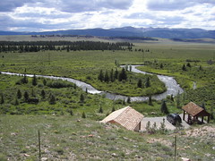
After crossing the Currant Creek Pass and one other "small hill", we were
rewarded with this view of the Platte River. Just beyond this is the town
of Fairplay, about 6 miles away.
Wednesday, August 16, 2006
IBEW Reunion
Bill Soux arranged the 2001 IBEW reunion. This is the model used for the
artwork on bandanas, t-shirts, mugs, etc. It was apparently a big hit with
the electrical brotherhood.
artwork on bandanas, t-shirts, mugs, etc. It was apparently a big hit with
the electrical brotherhood.
Bill & Matthew
At the Bull & Bear Saloon, we talked with Bill Soux, owner of the Guffey
Garage, B&B & Campground. He's lived in Guffey for 33 years and is still
not one of the "old-timers"
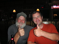
Garage, B&B & Campground. He's lived in Guffey for 33 years and is still
not one of the "old-timers"
Hog Barn
even the exterior says "Welcome to Guffey". This is the exterior of the Hog
Barn, our anniversary suite.
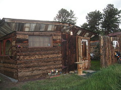
Barn, our anniversary suite.
Happy Anniversary, Honey!
We spent our anniversary in the Hog Barn in Guffey, CO after climbing 4,300
feet in 32 miles. Bill even put mints on the pillows (they lasted about 2
seconds).
feet in 32 miles. Bill even put mints on the pillows (they lasted about 2
seconds).
Guffey Garage
You can pick up anything you want at the Guffey Garage--providing you can
find it. Bill Soux runs the garage, campsites and B&B in town.
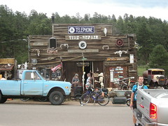
find it. Bill Soux runs the garage, campsites and B&B in town.
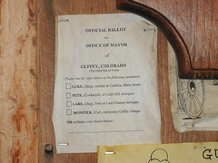
The Mayor of Guffey
is Monster, the cat. Matthew finds it necessary to hobnob with every feline
politician he can.
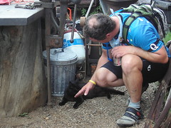
politician he can.
Yard Art in Guffey
Actually, the entire town of Guffey can be considered yard art. But this is
one that Bill Soux put up, near the B&B we stayed in. You're in the wild,
wild west now.
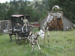
one that Bill Soux put up, near the B&B we stayed in. You're in the wild,
wild west now.
Post Office Block
This building is named Post Office Block, though the old post office sits
kitty-corner to it. Part of historic Canon City, this building dates from
the 1880's.
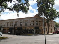
kitty-corner to it. Part of historic Canon City, this building dates from
the 1880's.
Fremont Art Center
At the Fremont Art Center in Canon City, George, standing next to Matthew,
was our docent. Elsie and Ted watched the front doors. The current exhibit
features drawings and photos from past and planned Christo & Jean-Claude
installations--including "Over the River", planned for the Arkansas River in
2010. (btw, no photos are allowed in the gallery. ignore the drawing
behind Elsie)
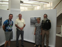
Garden of the Gods
If it looks like I'm about to fall off the rock, it's because I am. Hurry,
take the picture!
take the picture!
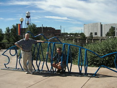
Pueblo Bicycle Parking
At the HARP (Historic Arkansas Riverfront Project) in downtown Pueblo,
they've got bicycle parking covered.
they've got bicycle parking covered.
Tuesday, August 15, 2006
North Park
Monday, August 14. Denver Creek Campground in the Arapaho National Forest, CO, to Walden, CO.
Camping at nearly 9000 feet makes for a cold night; in retrospect, perhaps I should have closed the vent when I woke up in the middle of the night because I was too cold. When we got up, the temps had to be in the low 40's, so we ended up putting on several layers each.
We paced ourselves up the 9.5-mile climb to Willow Creek Pass, taking a few breaks to shed layers as we warmed up. Just as we reached the point where we could see the pass, we noticed a cyclist gaining on us; this would turn out to be Roger, a local cyclist who lives in Granby, who happily took our picture in front of the sign indicating the Continental Divide (our second crossing) while he waited for his cycling companion Jim to finish the ascent. We talked with them for a while as we put our layers back on for the descent; turns out they do this climb FOR FUN. Roger had to turn around and head back to Granby, but Jim was going down the other side like us before coming back. He wanted to climb Willow Creek Pass TWICE. Once from EACH DIRECTION. FOR FUN. We wondered later when we would reach the point when we wanted to climb mountain passes for fun. We are still wondering.
We hoped to find a restaurant in Rand, and did -- but it was closed. We went to the Rand Store instead, which had some of everything. Snacks, books, apparel, windchimes, tchotchkes of all kinds. We ate a snack there and rested a bit before heading off on our way to Walden. We were just a few miles out when we saw Jim coming the other direction. He must have passed us while we were in Rand and then turned around up the road. We don't know how far he went, but at first we thought he had gone all the way to Walden before turning around, but later we realized that he couldn't have gone that far. Still, he was burning up the road compared to us.
The descent from the pass took us through more beautiful forest before spitting us out onto a wide valley, so suddenly that it took us both off guard. It reminded us both of the scenes we saw in Kansas, except for the mountains in the distance. Once again the vegetation was the dry, sagey variety, and even the occasional hayfields eventually disappeared. By the time we reached the Arapahoe Wildlife Refuge, the landscape had achieved a veritable desert-like appearance.
The wind built gradually until, after we had turned more northwards, it was a genuinely imposing headwind at nearly 20 mph. We had to stop almost within sight of Walden just to eat something, because the effort we needed to fight forward against the wind was so great.
We rolled in to the first motel we saw, the North Park Inn and Suites, which is currently under construction but still open. Although the AC doesn't work yet (it's not wired), we opened the windows and the door to get some circulation. The room has a shower, though, which is something we haven't seen in a few days, so we were happy to use it (and I suspect that made other people happy, too).
Walden is the Moose-viewing capitol of Colorado, we are informed. We have not seen any LIVE moose yet, but there is a moose on nearly every sign in town and a large stuffed moose outside the nice restaurant in town, the Moose Creek Restaurant. Inside, there are at least two moose heads on the walls, and chandeliers made from moose antlers. Looks like they do more than "view" moose here.
We will cross into Wyoming tomorrow on a route that includes just one small town in 50 miles, so we are packing some snacks for the trip. The next day will be a short one to Saratoga, where we hope to find a library to upload some pictures. If we don't find one there, then we might find one in Rawlins. Hopefully, we'll have some recent pictures up soon. More tomorrow!
Monday, August 14, 2006
Most Beautiful Day Yet
Sunday, August 13. Kremmling, CO, to the Denver Creek Campground in the Arapaho National Forest, CO.
In Dillon, when we revamped the remainder of the trip, we decided to stop halfway up Willow Creek Pass and camp, so that is what we have done. The facility, the Denver Creek campground, is a US Forestry Service campground, and is very well kept. We found a nice campsite not far from the bathrooms and community dumpster, but not so close that activity around them will disturb us.
Last night in Kremmling, we opted to eat at a local restaurant (since it was there, saving our camp food for when we really camp, like tonight); and when we returned to our "camp" behind the volunteer fire station, we could see lightning over the bluffs. The wind was pushing that system in our direction, so we moved our bikes and trailers under the covered area next to the building so they wouldn't get wet if it rained.
Well, it rained. It rained hard, and didn't let up for a couple of hours. While Nancy read by the light of our little Pak-Lite, I closed my eyes and tried to occupy my mind with a kind of engineering analysis of the tent: the resisting force of each of the tent stakes, the flexibility of the tent poles (did I mention the wind?), and the surface area of the tent exposed to the wind. I did this all while trying to maintain an exterior appearance of utter calm. Every so often, the outside would be lit up by lightning, and thunder would reverberate through the valley in a low rumble, audible over the pelting rain and gusty wind. It was a nice night.
This morning, we opened our eyes to a beautiful, clear blue sky, and cool temps. Breaking camp, we decided to go over to The Moose for breakfast, and we had a nice leisurely Sunday morning breakfast over the Sunday Denver Post. We didn't even hit the road until 10.
Like the Blue River yesterday, the Colorado River was our companion today as we rode. Several times we passed spots where we could see fishermen in the water, and other times just the river winding along in front of the mountains like you'd see on a postcard. At one point, we saw a large group of horses down in the valley with the river in the background; they looked like they had been posed specifically for people stopped at our vantage point up on the road. But they were real, real horses in a picture fit for another postcard.
Our route also followed along a set of railroad tracks; we knew they were active because we heard freight trains pass in the night in Kremmling, both before the rain and after. We weren't disappointed; we saw three freight trains and an Amtrak train go by while we rode. We even stopped at one spot and got a little video clip of the train approaching, including the sound of the horn. It was near a shooting range, where we had already stopped to record the sound of the shots as they echoed around the valley.
Between Parshall and Hot Sulphur Springs is a five-mile stretch of highway 40 that ascends through a canyon cut by the Colorado River. The rock juts up vertically on all sides, and the river gushes along down from the road. The rail line continues, not far above the water. Trees cling tenuously to the rock faces and at the tops where erosion has not yet undercut them; evidence of trees that have succumbed lie alongside the tracks and in the riverbed. And just as you emerge from this fantastic vision, you enter the town of Hot Sulphur Springs. We stopped there for an uneventful lunch.
Once we turned northward again, on SR 125, we saw a sign indicating that moose live in the area, and that shooting or possessing one was illegal. I laughed a bit at that: how would a possessed moose behave? We had just started the climb that would take us up towards Willow Creek Pass, through the Arapaho National Forest on the way, and where we would camp for the night, so we regarded this as the last leg of the day (which, psychologically, somehow makes the climbing easier. Don't ask me how.). As we ascended, the valley scrub brush and predominant desert-like terrain gave way to evergreens and lush creek-fed floodplain vegetation. We even saw a small group of bison grazing on a grassy field at the base of a mountain - another picture-postcard perfect scene. Every time we rounded a curve, another stunning view would present itself. It just got more beautiful with each pedal stroke.
We passed the first campground, the Sawmill Gulch campground, and could see many empty sites, which bade well for the campground just two miles further up the road. Still, it was nice to know that, even if our intended destination was full, we had a fallback site. But the Denver Creek campground had many empty sites as well, so we virtually had our pick.
So tonight we will hope the clouds scurry by and leave a clear night, so we can see the stars, and perhaps some of the Perseid meteor shower, which is reaching it's peak about now. Tomorrow we will complete the ascent to the Willow Creek Pass (and our second crossing of the Continental Divide), and then veritably roll all the way to Walden. We expect to reach Wyoming the next day, which will be the sixteenth state we will have visited, not counting the Canadian provinces of Quebec and Ontario or the District of Columbia. While I worry a little about the sparse population ahead (northern Colorado and most of Wyoming can still legitimately be called "frontier"), I know that we will prepare ahead of time for areas without services, and we won't push ourselves so hard that it could create a crisis. We should be through those areas in a couple weeks, and then should have phone service most of the way to the coast from Yellowstone. Until tomorrow!
Saturday, August 12, 2006
A downhill day
Saturday, August 12. Dillon, CO, to Kremmling, CO.
The vast majority of the ride today was downhill; the few climbs were manageable and helped to keep us on our toes. It was also cold, cold enough for us to each be wearing additional layers AND our jackets. The sky was overcast and we rode through a light rain much of the day, eventually deploying our new Camelbak rain covers (and finally figuring out how to attach them).
We started late, after 10, so the outlet mall was open as we went through Silverthorne; we stopped at a few places to see if they had the right kind of clasp for the BOB dry sack (we would like to lengthen the bottom rear clasp connector because it is so difficult to access), but no luck. So we rolled on out along route 9 towards Kremmling.
Our riding companion for much of the day was the Blue River, winding along the valley out of the Dillon Reservoir and down to the Green Mountain Lake. The outlet from the Green Mountain Lake presents a striking view down a breathtaking chasm, but just as we stopped to take a picture there, a security guard was on us and told us to keep moving. We were not allowed to stop on the dam that holds back the lake. He told us we could stop at the far end of the dam, but by that point the view was obscured by, what else, a mountain (Green Mountain, to be specific). So we kept moving. I suppose he was just doing his job, but I really can't imagine a less threatening pair than us; if we were bent on blowing up the dam, would we show up on bicycles? The day we look like a legitimate security threat is the day we have lost all reason.
In any event, we stopped in Heeney for lunch, on the shore of Green Mountain Lake. The two or three dogs wandering around the dining room occasionally stopped by our table to beg, but we resisted. Once again, we beat the lunch rush; we have had uncanny luck in this regard for virtually all of this trip. It is as though we go in, sit down, place our order, and then the rest of the town shows up. Today, when we went in, there was one other couple in the place; but within a few minutes after we had placed our order, two large groups came in and took over the room. A few minutes later, and lunch might have taken MUCH longer.
We crossed the Colorado River shortly before Kremmling; in fact, there was a marker indicating the "Colorado River Headwaters Scenic Trail", dirt roads that run alongside the river on both sides of the road we were on. It was fun to see the Colorado River in a place so far removed from where we kayaked it two Junes ago, while we were in Las Vegas on a company-sponsored trip. Then, we were on the river with Kurt and Holly (whom we saw in Burlington earlier in the trip), John (Gunnar), Ryan and Mike. Here, the conditions did not look conducive to good paddling - too shallow, many rapids, and lots of debris.
Tonight, when we arrived in Kremmling, we went first to the bike shop so Nancy could get her derailleurs adjusted (turned out she really needed a new chain). While she was there, I went to investigate the accommodations available for us. There were four motels in town: two that I wouldn't stay in at ANY price, one that was full, and one that was too pricey for what was offered. So, we decided to camp behind the volunteer fire department, hoping that there would not be any fires overnight. There are restrooms available with running water, a nice level grassy place for our tent (although I suspect it is a septic drainfield . . .), and a picnic table under a covered porch. The view beyond the outskirts of town is straight out of a western movie; chiseled sandstone bluffs and sagebrush. I took a few pictures and will post them when we can.
With our crossing of Hoosier Pass two days ago, we officially crossed the Continental Divide for the first of (at last count) seven times. We will cross it again the day after tomorrow at Willow Creek Pass; I'll make sure to mention every other crossing as they happen.
Nancy mentioned yesterday that we had reevaluated our route for the remainder of the trip, and had come up with a date for our arrival in Lincoln City of September 27. After coming to an understanding of what we were capable of doing in the mountains, our new projected daily average mileage from here on out is about 37 instead of 55. Part of that is dictated by what places are available for us to stop in, and where we can get water and other necessities; and as we proceed up through northern Colorado and southern Wyoming, we may encounter areas where we have no signal for our phone and will thus not be able to post every day.
Tomorrow we are heading uphill again towards (but not yet over) Willow Creek Pass. Our proposed destination is the Denver Creek Campground, a US Forestry Service facility, more than halfway up the climb. That way we will start the next morning with the worst of the climbing first, followed by a pleasant descent into Walden.
R&R&R in Dillon
Friday, August 11. Dillon, CO. Rest, Relaxation and Repair.
After a short trip from Dillon to Silverthorne, a welder at Cook's Welding confirmed our hope that my BOB trailer frame could be repaired. We were hoping to get a new bolt, to have a sleeve installed to reinforce the pipe,and the pipe cracks welded. What we got was the pipe welded together at the center connection. Not ideal, but I doubt that the welder had much experience fixing these kind of trailers.
So with that drama ended, we were able to turn our attention to enjoying the day in the mountains. The sun was out, but the air was still cool enough so that I wanted to feel the sun on my skin. Another beautiful day in the mountains.
While waiting in Silverthorne for the trailer, we found ourselves at a couple of nice outdoor gear stores. Both of these shops had a lot of great cycling items. Not surprising, since everyone around here is either on their bike or driving around with a bike tied to their car. Specifically, I was hoping that we'd find a new saddle for Matthew. His current one is failing fast, and I could just see a catastrophic failure in the middle of, say, Wyoming. Luck was with us--Mountain Sports not only measured his butt for a seat, but installed it and let him try it out on a trainer. It is so comfortable that he's already forgotten that he's riding a new saddle.
We also found replacement water bottles. We carry most of our water in our Camelback backpacks, but we have a couple of water bottles in cages on the bike, too. I'd noticed that the water in the bottles was starting to take on a plastic taste, so I was on the lookout for a Nalgene bottle. What we found was the best of both worlds--a Nalgene bottle with a Camelback sip-tube. The disintegrating plastic bottles were quickly replaced. A couple more Cliff Shot gels, a half-dozen Cliff bars, and a new pair of sunglasses for Matthew and we're all set. Matthew lost his last pair of sunglasses on the descent from Hoosier Pass. He'd stashed them on his head, threading the temples through his helmet's vents. As Becky noted, this is akin to leaving your travel mug on the roof of your car. This is his third pair for the trip--the first pair was left on the train in Philadelphia.
We even had time today for haircuts. Matthew's hair was already longer than I've ever seen it. He'd promised to let it grow out until we reached the end of the trip, but I could tell that it was uncomfortable for him. Every time he took off his helmet he'd ask "How's my hair?", so I was glad to see him shorn again.
We also shared ice cream with Becky and her boys, Kenny, Austin and Colin. They were passing through Dillon on their return to Lafayette. It was great to get to see them one more time.
We also spent a couple of hours tonight examining the remainder of our trip. It looks like we have about 1,700 miles left, which will bring our trip total to around 6,400. Since we'll be in the mountains for the next few weeks, we decided to scale back our daily mileage to try to enjoy the days. It looks like we'll be on the road another few weeks, with a planned arrival in Lincoln City on September 27.
That said, here's our last few mail stops: Rawlins, WY, zipcode 82301 West Yellowstone, zipcode 59758 Lolo, MT, zipcode 59847 Hood River, OR, zipcode 97031 Dried fruit and PayDay bars are most appreciated. If you send a care package, address it to Matthew Stovall, General Delivery, [city], [state], [zipcode]. Write on the package "Hold for Pickup". Thanks!
Friday, August 11, 2006
Passing Hoosier Pass
Thursday, August 10. Fairplay, CO to Dillon, CO.
Today's the day we climbed Hoosier Pass. It's 12 miles from Fairplay, climbing nearly 1500 feet. The storm that rolled through Fairplay last night really cooled things off, and so we started out wearing extra layers. Matthew wore tights over his shorts, and a windbreaker over his jersey; I added socks and a long-underwear top to my usual riding ensemble.
So we started out around 9am, and found the bIke path right outside of town. For six miles, we rode near the highway, but far enough away to miss the noise and the traffic. At the little town of Alma, at the end of the bike trail, we stopped to rest and get warmed up at the Alma Natural Food & Coffee Shop. The last 6 miles, to the top of the pass, would be even more steep than the first 6 miles.
As we sat in the cozy, warm shop, reading the Mountain Gazette, I wondered aloud if we were savoring the journey or delaying the inevitable. Eventually, we decided that it was the latter, and so grabbed our gear and headed back outside again.
The gray clouds had moved out already, and the sun felt warm. There was a pretty generous cross breeze that would keep the day cool. I had put on my jacket, leg- and ear-warmers, but had to stop pretty quickly to remove them. The climbing was really intensifying, and though turning the pedals didn't require a herculean effort, I couldn't keep my mph above 4. With a couple of short breaks, that's exactly how we climbed the mountain.
At our last stop, about a mile before the top, we pulled off to the opposite side of the road to catch the view back towards Fairplay. Yes, we had definitely climbed up a mountain. I was really beginning to believe that we'd make it to the top, and was pretty happy about the journey. I'm not much of a climber, so making it to the top of this peak is a huge accommplishment for me. As we stood looking back down the mountain, we spotted a cyclist coming up from Alma. We didn't stop her--she was on the opposite side of the road and moving at about twice our speed (She would crest the top and pass us again, coming back down the mountain before we reached the pass.).
At long last, our climb levelled out and we were at the top! A nice woman, traveling with her mother and a very friendly yellow lab, offered to take our picture at the summit, but the picture didn't take. I snapped one of Matthew before he jumped off the monument, tho--evidence that we did indeed reach the peak.
Two-wheeler had warned us of construction on the road down to Breckinridge, and just as we started down the mountain, we were stopped in the line of waiting vehicles. Only one lane of traffic was open due to the construction. One of the passengers in a nearby car came over to tell us we'd probably be waiting 45 minutes before the traffic began to move again. So we had some time to enjoy the view and savor the climb. It had taken us a little over 2 hours to climb 12 miles. The next 12 miles into Breckenridge would be all downhill, and then the final 15 miles would be generally downhill to Dillon.
Once the traffic started moving, we got in with the traffic and rolled down the next 2 miles in about 8 minutes. At a wide spot in the road, we pulled off to let our brakes and wheel rims cool off for a few minutes, and to add more layers of clothing. After the rest of the cars passed, we continued down the mountain to Breckingridge, shivering the entire way!
The staff at a local bike shop in Breckinridge gave us directions to the bike trail that would take us to Dillon, and we decided to press on. We'd hardly pedalled the entire way down the mountain, and apparently the dramatic drop in altitutde had also affected our judgement. Another 15 miles didn't seem like much. The bike route is really beautiful, snaking around the Dillon Dam and traipsing through a lovely forested area. The path was paved, but hadn't been graded, so we were rolling through some not insignificant hills again. Sigh. For a while, it seemed as though we were in for a rainshower, but only a few drops materialized. The weather did stay very cool throughout the day, and I was glad to have all of my layers.
At Frisco, we had one last chance for lunch before the last 7 miles to Dillon. We decided instead to split a (king-size) PayDay bar. Which meant that by the time we finally got checked into a hotel in Dillon, it was 4:30pm. We were both ravenous and exhausted.
The streets in Breckinridge have what amounts to gutters on either side of the street, and as we crossed over one of them, my trailer hit the lowerst part of the gutter hard. I couldn't detect any change in its' handling, but when we got to the hotel in Dillon we found that the BOB's frame had indeed cracked. I couldn't even contemplate the ramifactions of that discovery. First I would have to have food (and perhaps a fruity tropical drink).
Some hours and calories later, we have several plans. Plan A involves getting a welder from Silverthorn to fix the frame. Plan B includes a trip to Boulder to buy a new BOB. I'll let you know how it turns out.
Wednesday, August 09, 2006
10,000 feet. . . And Climbing
Wednesday, August 9. Guffey, CO to Fairplay, CO
Matthew's plan for today was to try to reach Fairplay, rather than stop in Hartsell. Looking at the climbing profile gave him confidence that we could make the 46 miles, even though we'd climb another 2,500 feet.
After yesterday's climb of 4,300 feet over 32 miles, I had my doubts. By the end of the day, my legs felt not wooden, but more like cast iron-encased wood. I was turning the pedals, but my muscles were not contributing a thing. The climbing profile for today showed a long descent into Hartsel, but there was a 20-mile climb after that into Fairplay.
I still had my doubts when we stopped in Hartsel; the morning's ride had a few more rolling hills than I had anticipated. As we sat in the town's cafe, I realized that we'd have to go on to Fairplay--Hartsel offered no lodging of any kind.
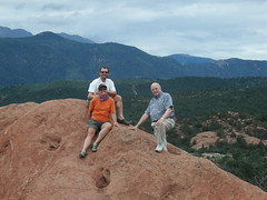
Still, here we are in the Rockies. We crested Currant Creek Pass after 11 miles, and stopped to enjoy the view. At the top of this pass, you can see the smaller hills, but there are more layers of mountains beyond. This is where you can see the end of the front range, and get an eyeful of the rest of the mountain range. It's the proverbial picture postcard view, enhanced the fact that we're this close to it (and possibly suffering from the elevation).
Anyway, the next 16 miles are "downhill", according to the profile. Not exactly--it still took us another 90 minutes to get to Hartsel for lunch at the bottom of the hill.
Luckily for me, the road to Fairplay started out with very gentle climbs. The first 10 miles took us through another beautiful valley, lush with green grass, colorful wildflowers and sleek, fat cows and buffalos. The morning's gray clouds drifted away, replaced by the fluffy, perfect-looking clouds that we've come to expect in Colorado. The mountain ranges ahead of us were again that majestic color purple, and we had a nice cross breeze and cool temps. My legs were contributing today; we were climbing virtually the entire time, but the climbs were a lot more manageable.
We crested another hill to see the Platte River snaking around the valley below us. I don't know what it looks like in other years, but the river today was moving fast and furious, twisting sharply one way, then abruptly twisting the opposite direction. The road below us plunged down into another valley, then in a straight line across the valley floor to--a city?
Yep, we could see Fairplay from the crest of that hill. Only 6 miles to go. Whoohoo!
The last 5 miles only looked flat. We could only manage about 6mph, on a road that looked flat, but had a very gentle upslope the entire distance. By the time we got to Fairplay, I was happy, but happy to stop, too.
Fairplay is an 1880's mining town that has survived better than many other towns like it in the west. Fairplay is a restored Western town, sitting at the junction of Hwy 9 and Hwy 285. They've capitalized on the western theme, and also created a whole festival celebrating the burro--in particular, one burro named Prunes. Unfortunately, we just missed Burro Days--it's held the 3rd weekend in July.
We had dinner tonight at the Hotel Fairplay, since almost every other eatinig establishment in town is either closed on Wednesdays or just closed. The hotel dates from 1922, when it was rebuilt after a fire swept through the town and destroyed the original hotel. The hotel is built on the foundation of the original, and looks identical to it. The new owners added modern conveniences in the rooms, and added a great bar off the dining room. It's a charming hotel, and the dining room features homemade pies. I recommend the oatmeal pie. Similar to pecan pie, but substituting raisins and oatmeal for the pecans.
As we enjoyed dinner, the skies darkened with storm clouds again. We saw lightning strikes in the distance, and could see the rain already covering the towns we had ridden through today. The temp has already dipped from 75 to 59 as the rains move in.
Tomorrow we head for the highest point of our trip--Hoosier Pass. From Fairplay, it's a 12-mile ride to the top, climbing from about 10,000 feet to 11, 542 feet. From there, it's all downhill, theoretically. We'll stop in Silverthorn for a rest day on Friday, to celebrate our passage through the Rockies. We'll still have a few more days in the mountains, but the big hill will be behind us. I'll drink to that.
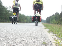
This gravel is surprisingly soft
Tuesday, August 8. Canon City, CO, to Guffey, CO.
I'm the mayor of Guffey's new best friend. His name is Monster, and he's a cat; he lives at the Guffey Garage, where we went to talk to Bill Soux about a cabin for the night. Seems all it takes is a knowing scratch on the head and he's like putty in your hands. I'm not interested in political manipulation, of course, but if I wanted to I could rule this town. Maybe. With cats, you never really know where you stand.
But we are here in Guffey, that much should be clear. There were times today when it was not certain we could actually get here. We managed a sparkling 6 mph as we climbed a net 4300 feet in just over 32 miles; some of the climbing was so long that we had to take more than one break during the ascent. I am not ashamed to say that I walked my bike for some stretches. Not that any of it was particularly steep; it was never so steep that we couldn't ride up it like some of the slopes we encountered back in PA. But, these were LONG climbs. LONG. From near the point where SR 9 intersects SR 50, it rises inexorably for about 11 miles.
But enough about the technical aspects. While it rained last night, this morning was the first truly cloudless morning we have seen in this region. Bright blue sky and a gentle breeze, and temperatures not yet above 80 made for a nice morning's ride. We already knew about how far we would go before seeing the rafting spots and the campgrounds we thought we were going to last night. When we got to that point, about 9 miles into the ride, we had already been riding for over an hour and a half, and both of us had consumed about a third of our water. So we stopped at a rafting outfit to get some water and a Gatorade. There we met numerous people, all preparing to risk life and limb rafting down the Arkansas River in Class III+ rapids, who were amazed at OUR trip. Go figure.
It was a good thing we stopped for water then, because we both ran low about 4 miles from the end. But at the time, it just seemed like a good precaution. When we left and turned onto route 9, the Currant Creek valley suddenly opened up in front of us like a hidden desert garden. As we climbed the first few innocent miles, at gentle grades, we passed much scrub brush and many low, gnarled trees, stunted by years of insufficient water and downslope winds. This type of vegetation gradually gave way to larger cottonwoods and leggy grasses, and some varieties of cacti. It was not what I expected; I was expecting more pines and lush vegetation (it would come later).
We took several breaks as we ascended; at one spot, most of the way up, we found a relatively wide spot in the road and stopped to rest. There wasn't really anywhere to sit, so we tried perching on a nearby rock for a little while, before finally settling for sitting on the road shoulder. Nancy placed her Camelback behind her, like a pillow, and laid out along the shoulder on the gravel; after a moment, she remarked that "this gravel is surprisingly comfortable", which, under the circumstances, was absolutely correct. We stayed there a long while, long enough for several cars to pass; I suppose none of them thought anything was wrong, or else they would have stopped.
Just as we entered Park County, we crested an intermediate rise and were pleasantly surprised by a nice, fast descent. Of course, that meant more climbing, but after plodding along at 3-4 mph for so long, seeing 38 mph was fun. We climbed up the other side and then had another nice descent. This feature, we would learn later, is called the "Guffey Double Dip". From there, it was mostly level to moderately uphill to the road to Guffey. We worried aloud that the road to Guffey might be a mile-long downhill, leading to a morning climb, but in fact it is the opposite. We will have a nice roll out of town in the morning.
As we entered Guffey, we stopped at the first place we saw that we recognized from our guidebook - Peaceful Henry's Mountain Inn. Closed. We could see a sign for a general store down the street, so we stopped over there to ask about where to go; Mary, the bartender/waitress at the Bull and Bear Saloon (which is what it turned out to be, not a store), told us about Bill Soux and then called him to make sure he would be there before sending us up there. Bill also owns the garage, where Monster lives; and before he showed us the Hog Barn (where we would be sleeping - sounds promising, doesn't it?), he invited us in to the garage for some water (Nancy) and a beer (me). Even though it was Milwaukee's Best, much lighter than I usually prefer, it was about the best thing I'd tasted in many miles. And, at an elevation of 8600 feet, one was plenty.
We also met the husband-and-wife schoolteachers who run the charter school in town; though they live 45 minutes away, they happened to be in town building a new playset in the playground. They are also bicycle tourists, and were curious about our trailers (they have a tag-along for their four-year-old, and want to put a trailer on the other bike for touring). We got to talk with them for a good bit before they had to go home. Bill showed Nancy the cabin while I was talking to them, and then she showed it to me.
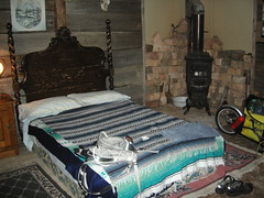
The Hog Barn, as it is known, is great. It has one queen-size bed (no frame or headboard, just the box spring and a mattress), a dresser, a TV with a VCR (several tapes provided), a microwave, a coffeemaker, and two chairs. The outhouse is just yards away; the shower is between the outhouse and the cabin. Nancy took some pictures of the shower because words are inadequate to describe it; suffice to say that it was perfectly refreshing for us, but Pam Dunkerly might have trouble using it. Nancy showered first while I sat near catatonia in the cabin; then, when she returned, I gathered my clothes and toiletries, and Nancy came with me to the shower to show me how to use it.
Notice what I forgot to bring with me to the shower (I'll pause a moment so you can check). Like I said, the shower was refreshing, and I thought I was so clever finding a way to conserve water (by turning the shower head to restrict flow while I soaped up, like in the Navy). But then I rinsed off and shut off the water; and as I did, I realized that I had forgotten to bring . . . A TOWEL.
Some of you who know me (or who are related to me) are familiar with a particularly embarrassing moment I experienced as a child (age, I don't recall), when, while visiting my Aunt and Uncle at their Oregon mountain home, I became trapped in an outhouse. The latch on the outside had fallen and caught, and I could not open it. At first, I was not terribly alarmed, since there were . . . MAGAZINES . . . to read, and I figured someone would notice eventually that I had been gone for a while. But then, after quite some time, when nobody came to rescue me, I started yelling and banging on the outhouse door. Finally someone came to open it (I think it was Mark). In any event, it was embarrassing to have been trapped in an outhouse with a pile of Playboys and screaming to be let out.
So there I was, drenched but clean from the shower, and abruptly realizing I did not have a towel. I am pleased to say that I was actually amused with the situation. I called out to Nancy a couple times, hoping she was outside, but to no avail. It reminded me of the "outhouse incident", which just made it funnier. Ultimately, I just air-dried to an extent that made it possible to dress (since all our clothes are quick-drying).
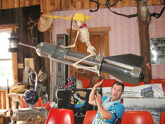
We ended up at the only place open for dinner, the saloon. While we were there, a family of four came in; they were anxious to plug in the singing deer head. You read that right: the SINGING DEER HEAD. On first glance, it looks like an ordinary mounted deer head, much like the ones that are mounted in the offices of my former employer, PPI (which is why I barely noticed it, or the plug that conspicuously runs out from the base). But when it gets plugged in and the proper button on the remote (!) is pushed, it sets into motion a sequence of songs and bad puns ("I'll head 'em up and you move 'em out! Get it? HEAD? Ha ha ha ha ha!"). As you can imagine, this is only entertaining for a little while (perhaps longer for some), and eventually someone unplugged it. I swear it wasn't me. I wasn't watching what Nancy was doing.
Bill, our host, eventually showed up at the saloon, and we got several good stories out of him. He has hosted a reunion of IBEW workers a couple of times (we are talking about 1200 people here), and told us about some of those parties (and parties they were). He also filled us in about the road ahead; we can expect narrow roads between Alma and Hoosier Pass, but otherwise we should be fine.
Tomorrow, we will decide whether to stop in Hartsel or in Fairplay depending on what we feel like when we get to Hartsel. The profile looks like we should have a 10-mile climb in the morning, followed by a long descent into Hartsel and a little beyond. The climb up to Fairplay looks like it's about halfway up to Hoosier Pass, so we'd really like to get there. Then we'd be able to get to Silverthorne on Thursday so we can have an extra day there, and meet Becky on her way back from Utah on Friday. Maybe I can get my hair cut - the last time I got it cut was in Rhinebeck, New York. It's getting pretty unruly. Nancy thinks it's cute. More later!
Subscribe to:
Posts (Atom)