Wednesday, July 19, 2006

Prairie Lick

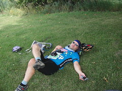
Wednesday, July 19. Hartsburg, MO to Sedalia, MO.

The plan today was to ride 50-some miles from Hartsburg to Pilot Grove, continuing along the Katy Trail. We spent a restful night in Hartsburg, since the only thing in town open was The Hitchin' Post. The Hartsburg Inn, where we stayed, was very comfortable, but in most states, converting your garage to a bedroom and bathroom does not qualify your establishment as an "Inn".

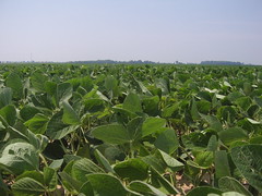
We were out on the trail by 7:00am, and spent the first 2 hours in relative coolness and shade. Like yesterday, we were the first humans through the trail, and were covered in fine cobwebs in no time. Riding with our bandanas pulled over our faces (a la cattle rustlers) gave us the protection we needed from inhaling or ingesting too many of them. We didn't expect to see any locals on the trail today, due to the heat. Today's heat index of 111 would have kept any sane person off the trail.

And so it began to look as though our ride today would be scenic but uneventful, and we'd be off the trail right around lunch. It's nice to have a plan--otherwise, you wouldn't even get out of bed, would you?

Today's route was very scenic, and also historic. We rode along the Missouri River for some time, and passed an actual campground where Lewis and Clark and the Discovery Corps stayed in 1804. High up on one of the bluffs, a natural stone archway can be seen. The arch has been noted by every explorer who's come this way, and I'm noting it here so as not to break the chain letter. Explorers before L&C's time named it the Roche Percee (pierced rock), and the name has stuck. A town just beyond the arch is named Rocheport, and we stopped for a quick break there. They have a very nice little depot at the trail, complete with A/C, a cafe, bicycle shop, restrooms and city hall. Larry, whom we had met two days earlier at Defiance, showed up with his wife. He had finished up yesterday's ride in Rocheport, and was heading back to his home in Colorado today. He too had found the lack of services on the trail was a problem. By the time he got to Hartsburg, where we stopped for the night, he was out of food and low on water. Since the Hitchin' Post wasn't open when he came through Hartsburg, he continued on another 20 miles before stopping. We chatted for a bit and met his wife Jane, who had been SAG'ing his trip on the Katy Trail. It was here that Matthew broached the subject of continuing on to Sedalia instead of stopping at Pilot Grove. It would be a long day, but it would make tomorrow's day very short. And since we'd gotten such an early start on the day, another 25 miles wouldn't be too bad, would it?

It was now about 9:30am, and the trail was heating up. We shortly came on to a really stunning view of both the river on the left and the bluffs on the right. There is a natural water supply and the Lewis & Clark Batcave below the bluff, level with the trail (really. Go look for yourself). The cave is on private property, so I could only get a quick peek into a dark cave, but about 50 feet above the trail on the bluff were remnants of Indian pictographs. L&C did not mention them in their journals, but other explorers did make note of them. It's possible that they were made after the Discovery Corps came through the area. The bluff is exposed to the river, and easy to see from a distance. Matthew speculated that the pictograph may have indicated the presence of clear water to other river-going Indians. It's a beautiful spot, and we spent some time looking around the site.

The shade was giving out and the heat was rising, so we pushed on. We did see a couple of locals out on the trail, and a pair who looked like they might be touring. They blew by us as though we were invisible, but with them out of the way, we could concentrate on the small figure further up the trail. As we got closer, I saw a backpack left in the shade, and a lone figure, walking in the opposite direction. We stopped for a chat, and discovered that Uma and her dog Flossy, are walking the country from Wyoming to the East Coast. She's from Ashland, OR, and last year walked from OR to WY. This year she's completing the journey, and had just found the Katy Trail about 5 miles earlier. Flossy had run off to spend some time in the shade, and Uma was going to collect her. We exchanged contact information, wished her a good trip, and headed on. Boonville was only about 5 miles away, and it was still before noon. We decided to have a quick snack, and wait for lunch until we got to Pilot Grove, another 11 miles down the road. As we pulled up to the restored depot, we saw a restored caboose and decided to look around while snacking.

I've never been inside a real caboose, and this one looked like it could be pressed into service at any time. Another visitor came in while we were there, and she told us about her first train ride from Kansas City as an 8-year-old girl. She hadn't heard about the rail line being converted to a bike trail, but said she could see herself riding the trail with us.

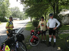
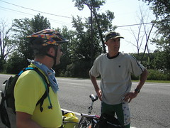
And as we climbed down from the caboose, another couple of riders pulled up to the depot. Joe and Pat are 5th and 3rd grade teachers from Glenwood Springs, CO, and were riding the Katy Trail in the opposite direction from us. They had started with BOB trailers and another friend, but the friend wasn't feeling well and decided to follow them in a car and take their trailers with him. They were meeting in Boonville at the depot to have lunch in town. They assured us that the trail ahead of us was mostly shady, and we'd have no trouble making it to Sedalia. Good thing, because now it was almost 1:00pm.

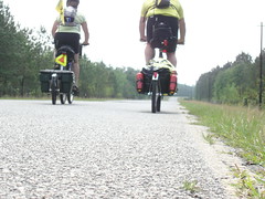
The trail out of Boonville was shaded, but we'd already done 40 miles and the heat was beginning to break me down. And was I imagining it, or was the trail sloping up?

We passed by, or through, maybe, a little burg named Prairie Lick. There was nothing trailside that would indicate that the town still existed, but when I saw that name, I knew that was the definition of today's ride. Hot and dry. We'd both filled up our Camelbacks with ice and water before leaving Hartsburg. Matthew carries 100 ounces, mine is 72 ounces. By the time we reached Boonville, we were both out of water, so we refilled there. What we needed now was lunch.

Pilot Grove was now in sight, and we found The Lunch Box Deli right off the trail. A sandwich, chips, and a chocolate shake all tasted great, and a I had a bottle of water, too--just in case. We got some ice from the deli, and filled up with water one more time before hitting the trail.

Clifton City was 12 miles from Pilot Grove, and Sedalia another 12 beyond that. Turns out that I had not been hallucinating about the trail slope--we were riding the last licks of the Ozarks. From Pilot Grove to Clifton City, the trail rose gently for long crawls, but then sloped back down for pedal-free periods. The trail was canopied in shade for the majority of the 12 miles, but when the canopy disappeared, we felt the lash of the day's 111-degree heat.

The last 12 miles into Sedalia took us out of the rolling Ozarks remnants and into the flat, broad Osage plains. While this meant we had less shade, the breeze helped keep the temperature bearable. The Katy Trail dumped us onto the city streets in Sedalia, and we found ourselves at another restored depot, where the Sedalia Chamber of Commerce has its' office along with a museum and gift shop. All closed, since it was now 6:00pm. There was a spur of railroad track outside the depot, with a sculpture celebrating "The Cradle of Ragtime Music". Scott Joplin wrote "The Maple Leaf Rag" while living in Sedalia. Further along the depot's plaza is another large sculpture, created from iron. The sculpture was a collaboration between local schoolchildren and a sculptor. The iron piece is difficult to describe, and difficult to capture with my camera. In a roller-coaster type of design, a collection of characters are dancing along this rail line. Characters including musicians, children, chickens, pigs, bunnies, horses, dogs and cyclists mix with iron images of the MK&T trains and the (historic) Hotel Bothwell. Which is where we are staying tonight. The hotel was originally opened in 1927, and restored in 1999, with 48 rooms, the Ivory Keys Lounge, an Italian restaurant, and coffeeshop. It was in this hotel that Harry Truman found out that he'd gotten the nod from the Kansas City political boss to run for the Senate. He'd go on to serve two terms in the Senate before becoming President.

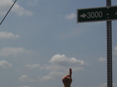
So after a very long day in the saddle, and 75+ miles in the heat and humidity, we're in Sedalia. We have one more day on the Katy trail, less than 40 miles. Then we're on to Kansas. I've heard from several sources that the heat is supposed to break in the next day or so, and Joe & Pat mentioned that the humidity tapers off after we reach the 3000 ft elevation. We will continue to watch our hydration levels, and hope for cooler temps. Right now, though, I can hear my pillow calling to me. More later from the dusty trail.

Tuesday, July 18, 2006

Like a Restaurant with No Food

Tuesday, July 18. McKittrick, MO, to Hartsburg, MO. The heat is on, that's for sure. Today, the heat index was supposed to be 111, so we knew we would need to get an early start; with blueberry muffins and banana bread to fuel us, we headed out at around 7.

Being the first humans out on the trail for the day is a dubious honor; mother nature hasn't really cleaned up, and the trail, sheltered by trees on both sides, is strewn with spider webs. As we rode, we broke them in great numbers, and by the time we made our first stop at about 18 miles, we were both covered with the fine strands. Of course, you can't collect spider webs without collecting the odd spider, and I found a few. It was another 45 minutes before we saw anyone else on the trail - headed in the opposite direction, which meant no more spider webs. Joy!

As we pedaled, we saw more turtles, a few snakes, several rabbits, many more indigo buntings, some cardinals, and two mastodons. Nancy says they were tractors with tree trimmers. Pfft. I know what I saw.

In the late morning, the bugs really emerged; there were flying insects of all shapes and sizes and possessing wingspans measuring in the inches, many of which remained perched on the ground until they sensed the approach of our tires. Only then did they choose to launch themselves into the air, careening into erratic and unpredictable flightpaths that invariably led to impact somewhere on me. They bounced off my arms, my legs, my chest, my face and neck; the only upside is that their wings are typically large enough to prevent them from being ingested like their smaller brethren to the east.

Many miles separate the designated trailheads, and the services available at each are sparse. We are using a trail guide we obtained yesterday that indicate what services are available at each trailhead, but not what establishments offer each service. So, relying on the indication that food and water were available at North Jefferson (across the river from Jefferson City, the capitol of Missouri), we headed there for lunch. Little else was available in between there and our rest stop at Mokane, and being close to a major city like Jefferson City made the prospects seem bright; but it was not to be. Although the "restaurant" column is checked on the map, no restaurant exists in North Jefferson. Further, it is nearly impossible to cross the river to the capitol, unless you call for a taxi. That runs about $10, unless you have trailers like we have, which would incur an additional charge - so instead we snacked on what we had and decided to continue the 10 miles to Hartsburg, which also indicated restaurants. The water fountain at the trailhead, too, did not function, so we were left to rely on the little water we had left for the rest of the way. As it turned out, we both ran out before we reached Hartsburg.

Which brings me to the name of this entry: Like a restaurant with no food. The Katy trail is a 225-mile trail, ostensibly intended for walkers, joggers and cyclists. However, the trailheads and burgs located along the trail are so few and offer so little, that riding between them could be a real strain unless you happen to carry a couple gallons of water with you. Despite that fact, the Katy trail is touted in travel and cycling periodicals as a good touring option. We decided, under the circumstances, that the trail is a lot like a restaurant that requires guests to bring their own food. There were times when we really would have liked to stop for some water, but nothing was open. We just happen to be on the trail on Monday and Tuesday, when virtually everything on the trail is closed. Tomorrow should be better, but the fact remains that there is a structural defect in the design of the trail in that the services are so sparse that it makes recreational use a serious difficulty (except near St. Charles), and touring a struggle. One simple improvement would be to put running water at the trailheads.

We managed to finish today's ride before 2, and got to our lodging for the night to find two cold bottles of water and some homemade chocolate chip cookies. However, our lunch options were nil; Dotty's cafe is closed on Tuesdays, and the Hitchin' Post, a bar across the street from the Post Office, didn't open until 4. We took the opportunity to wash our bikes and lube the chains, and then take showers before heading there shortly after they opened.

The fare is typical bar food, but an idea struck me (since our lodging does not include breakfast) - we ordered a pizza and will put it in the fridge in our room for breakfast. That and some oatmeal should get us far enough for lunch in Boonville, along with some snacks.

Tomorrow night's destination is the decidedly larger Pilot Grove, some 50 miles from the end of the trail in Clinton. We are on target to finish the entire trail on Thursday, and enter Kansas by the weekend. Reports from locals seem to suggest that the heat will break by then, so perhaps the beginning of our ride into Kansas will not be so sweltering. Two Wheeler warns us that trees are sparse as we head across the plains, so we will have to continue our early starts and early finishes so we don't bake. More tomorrow!

Monday, July 17, 2006

Hitting the Dusty Trail, MO

Monday, July 17. St. Charles, MO to McKettrick, MO.

Today is a rest day for the Tour de France, but not for us. We finally found a hotel yesterday that has the OLN channel in its cable lineup, and enjoyed watching the tour coverage of Stage 14. Hated to see the big crash that took out half the breakaway group, though. Don't know if we'll be able to see Stage 15, tomorrow. Go Floyd!

We got up early, knowing that the day was going to be another hot one. This is our first day on the Katy Trail, and we've been anticipating this ride for a long time. The Katy Trail is the country's longest rails-to-trails project, turning the railroad bed of the former Missouri-Kansas-Texas (MK&T) Railroad into a 225-mile-long bicyle trail. In 1986, the railroad ceased operations on the railroad, and in 1999, the Katy Trail was officially opened. Many of the towns that had depended on the railroad are now seeing new commercial traffic from the many cyclists who ride the trail every year.

After breakfast we found that the St. Charles trailhead was about a half-mile from the hotel We got to the trail just before 8:00am, and as our tires touched the dusty trail, we heard the crunch of the crushed limestone underneath our wheels. This surface is similar to that on the Erie Canal towpath trail, and in no time at all, everything from our knees down was soon covered in a fine white powder. On this type of surface our speed is reduced, but riding in the cool shade was worth the tradeoff. (Matthew's original plan had been to cross Missouri by going through the Ozarks, so a flat, shady path by the river makes him look like a super-genius). There was some local trail traffic on the trail for the first hour or so, but once the heat of the day started to rise, trail traffic became very sparse.

The trail winds past the Missouri River, in the same places where Lewis and Clark's Discovery Corps traveled the river. From our perch on the railbed, it's very easy to imagine their 3 boats sailing this waterway, past Daniel Boone's family land. By the time the Discovery Corps sailed the river, this area was already being farmed. The rich bottomland here still supports crops such as--you guesed it--corn.

Wildlife invetory on the trail today is big: several turtles, including one who was playing Katy Trail's version of Frogger, numerous snakes, a handful of bunnies, one deer, a rasher of lizards, an assortment of squirrels and dozens of indigo buntings, cardinals and one wooly mammoth.

At the trail head in Defiance, I saw a sign for Ted Drewes' Frozen Custard. Even though it was only 10:30am, I was stopping for custard. According to our friends in the know, (5, hollz) Ted Drewe's is the best custard in the country, made In St. Louis and coveted by St. Louis-ans. Since St. Louis isn't on our triptik, I took this chance as a sign from God, and immediately got off the trail.

Once we had our snacks in hand (custard, Grafton peach, Gatorade, Twix), we stepped out of the store and met Larry and Andy. Andy is turning around at this point on the trail to return to St. Charles, while Larry is continuing on to Hermann, which is across the river from our intended stopping place in McKettrick. They met last year on a cross-country bicycle trip, and have remained friends since, getting together to ride in different parts of the country.

Right after we got back on the trail, my BOB trailer tire went flat. We found a shady place to stop, and then changed the tube. Neither of us could see or feel anything on the tire that might have caused the flat, though, so we continued on with fingers crossed (mentally).

The route continued to meander between the Missouri river and fields of corn. We passed a tall bluff with a number of farm buildings at the top of the bluff. Each of them was meticulously maintained, but the one closest to the trail side had been painted to make the windows look like eyes, and a corncob pipe protruding from the "mouth" of the barn. I think I got a pretty good picture of it; I'll post it when I get the chance.

The natural features of the trail don't need any artificial enhancements. We came upon a gorgeous dolomite bluff on the side of the trail, and without a word, we both immediately stopped. The white-ish bluff was about 75 feet tall, supporting a prairie meadow and several trees on top. Again, I think I got a good picture of it to post here.

We stopped for lunch in Augusta, at the Augusta Microbrewery. Judging from the newspaper accounts that had been framed, gifted to and are hanging on the brewery wall, there has always been a brewery in Augusta. A German brewery, with a very good reputation. Matthew had one of their Tannhouser Pale Ales and enjoyed it a lot. But also decided against having beer at lunch anymore, particularly when it's this hot.

As we left the brewery, we stopped to talk with a couple of men and their kids, out on the trail for a ride today. The conversation was the usual "where'd you start, where're you going", followed by "that's quite a trip" and "I'd love to be able to do something like that when the kids get a little older". Seems like the Katy Trail provides a lot of people with a lot of opportunity for touring with kids.

As we were getting back on the trail, a van pulled up and the driver called out that my trailer tire was flat again. John, from Tulsa, pulled in and immediately offered us his tire pump. We pulled the tire off again, and this time Matthew found the hidden piece of glass that was causing the flats. While we changed the tire, we chatted with John. He'd done several cross-country bicycle tours, and one US-perimeter ride before he was 24. Then life intervened, in the form of marriage and family. But he's never lost the desire to tour, and now he's getting back into riding with his wife and 12-year-old son. He was driving the SAG wagon for them today as they rode the Katy Trail, as an introduction to touring. We thanked him for his help, and got back on the trail, where we soon met his wife and son taking a break in the shade. The heat was getting to them, it seemed; they were not too talkative. We wished them good luck and pedaled off.

Just a short time later, we met Greg Long and his son, Tim. They're from Kankakee, IL, where Greg is a Biology professor at a college in Kankakee. They're on an 8-day tour of the Katy trail, riding from one end to the other and then back to the beginning. They looked like they were enduring the heat pretty well, even camping out (without A/C!) while on their trip. Matthew asked how the dust was affecting their drivetrains; seems they had not had any difficulties. Greg had figured out a very clever, but simple mudflap for their fenders, and it was really doing the job keeping their chains clean. We wished them happy trails and headed on down the route.

The heat index today was 106, and we felt it. But we still had about 20 miles to go, and the shade was getting more and more scarce. The trail had shifted inland a little, too, so any breeze we might have had off the river had disappeared.

As we got closer to a bridge, we could make out two more touring cyclists, so we had to stop. Claudia and Rick are on the last few days of riding the entire Lewis and Clark trail. Claudia, Rick, and another couple had started together in Astoria, OR. After two weeks, the men had to return to their jobs, but the women continued on. A few days ago, Rick was able to rejoin Claudia when her girlfriend left the trail. They'll finish up this weekend, and head back to Indianapolis. We enjoyed hearing about the L&C trail, and I asked Claudia to put up her notes on a blog so that I could read the whole journey.

After that, we slogged our way thru the last 20 miles in scorching heat, stopping at Treloar for a quick break. Treloar, unfortunately, is closed on Monday, but thanks to Rick, we knew where to find the water pump and refilled our Camelbacks for the last leg of the trip. We finally reached McKettrick, and asked for directions to Penrod's View, where we were to spend the night. We had to push our bikes up a rutted gravel driveway, but once there we found Sherry and Ray to be very accommodating hosts. We are staying the night in the "guesthouse", a 2-bedroom house complete with kitchen and living room. We took showers, and then Ray was back to pick up our laundry(!) and leave us a plate of cheese, crackers, summer sausage and fruit. Then he drove us to Hermann to a Mexican restaurant, where we had the best Mexican food I've had since Rachel Q's kitchen. Our driver picked us up, and by the time we got back to the guesthouse, Sherry had delivered fresh-baked muffins for the morning--and our clean laundry.

Tomorrow's ride will continue on the Katy Trail. I'm looking forward to seeing more of the flat (and hopefully shady) parts of Missouri.

Sunday, July 16, 2006

Welcome to MO

Sunday, July 16. Carlinville, IL to St. Charles, MO. On a day we knew was going to be hot hot hot, we got an early start for a change. We were still a little unsure about how far we would actually have to go, but I was confident it was within our capabilities. We were actually on our way before 7 this morning, a bright and clear morning, already sweltering in the open sun but still cool in the plentiful shadows.

An interesting feature of Carlinville is the Standard Addition, a large collection of Sears homes dating from 1918. Back in the day, Sears sold ready-made homes (some assembly required) through their catalogs; Standard Oil, needing more coal than they could already get at available mines, opened two mines in southern Illinois, one near Carlinville, and ordered a number of Sears houses to make available for the miners. It raised the population of Carlinville by 50%. After about a decade, Standard Oil decided it could buy coal cheaper than it could mine it and closed the mines, and the miners moved on, leaving the houses to fall into disrepair.

Most of the houses have now been restored; all but 4 of the original 518 houses are still there. Riding through the neighborhood early in the morning, amidst the trees and quiet streets, was a really nice start to the day. The Sears houses are all two-story homes and have unique architectural details, especially in the roof eaves and front porches; we got some pictures of a few models and will post them soon.

We had been warned about the hills on Shipman Road, and they are hills worthy of the name. I was thankful for having them in the morning while it was still cool.

We had to stop at a sign that 5 will appreciate; it was a street sign denoting "Blues Lane". We got some pictures of that, too. It was near a cornfield, which raised a conversation we'd been having about the economics of corn farming (see what bicycle touring can do to a person?). So, we have a number of questions now.

For one, how many ears of corn grow on a stalk? And, how many stalks fit in an acre? How much of what we are seeing is "feed corn", intended for cattle feed, and how much is for human consumption (corn on the cob, canned corn, popcorn, and so on)? How much does the farmer make on the various kinds grown? There's more, but you get the picture. I shudder to think what will happen when we get to Kansas.

When we stopped for lunch, it was just before 11 and the temperature was 92. We had both sucked down lots of the water we had started the day with and gladly replenished it at Fran & Marilyn's in downtown Jerseyville. We stood out in sharp contrast to the vast majority of the client�le, dressed for church; but we had the conversation with many of the folks there. We also got some good recon on our intended route to Grafton, where we would take a ferry to Missouri. We were alerted to the fact that we had some more hills ahead and could not avoid them, and that they were more severe than the ones we had pedaled earlier today. Otterville Road, as it is known, was indeed a challenge, but we were able to find solace in the shade of a great tree along the way, cooling off a little in the breeze. The water in my squirt gun had gotten regrettably warm and wasn't helping Nancy cool off any, so I took a good long sip from the icy water in my Camelback and spit a long stream at her. It helped, but not before a moment wherein I feared for my life.

We had been alerted, also, to the fact that a long downhill would take us into Grafton. True; it took about five minutes to make the full descent, through trees and rocky bluffs, to the riverside town. This is the area where the Illinois River meets the Mississippi River, and a little ways down from here the Missouri River joins the other two. As we rolled into town, we needed directions to the ferry, so we stopped at a shop on the corner to ask. They happened to be selling fresh peaches; we got two and ate them right by the river. They were so juicy and sweet with a little tartness, Nancy said they were just about perfect.

We also got to dangle our feet in the water for a little bit; the water was pretty warm, but still a nice distraction from the now 100-degree-plus heat. There were dozens of people out on boats and jet-skis, and traffic in and out at the boat ramp was steady. We finally saw the ferry coming in - a barge, being pushed by another boat, open on both ends with a hinged ramp that slides up on a ramp on the shore, so cars can drive on. This arrangement leaves a gap between the ramp and the body of the barge - it will become important in a moment.

We rode down the short gravel road to the ferry and rolled on with five cars. We stood at the front to catch the breeze and see where we were going; and as I spoke with the driver of one of the cars, Nancy remained at the front. Just moments before, a jet-ski had passed in front of the barge and left large wake-waves; one of them hit under the front of the barge just right and sent a spray up through the gap at the hinge, half-drenching Nancy. After the shock passed, she realized she was disappointed at only being half-drenched. By the time we reached the Missouri side, she was almost dry; the ferry ride is less than ten minutes.

I was under the impression that we would be put ashore some ways up the Mississippi River, but in fact the ferry went pretty much straight across. In retrospect, that makes sense, but I still didn't know quite where we were. Ultimately, we found ourselves on route 94, and guessed we should go west. It was marked as the Lewis and Clark Historic Route, and we got a picture of the sign to post later. We had to ask directions but found we had chosen wisely, since west took us to St. Charles.

Tomorrow, we will begin riding the Katy Trail. Camping along the trail is not generally allowed, and the accommodations that are available seem to be B&B's - not sure why. We intend to get to McKittrick tomorrow, some 62 miles from here. We will again start early to beat the heat.

Tour de France note: the angel who helped us in Denver, PA, Sandy, sent us a note about Floyd Landis contending for the win in the Tour. He is from that area of Pennsylvania, raised a Mennonite; in fact, the very shop where Sandy took me to get Nancy's trailer tire fixed has several Floyd Landis items on their wall, and it turns out that early in his career he rode for the team at that shop. Thanks for the note, Sandy; we'll keep rooting for Floyd!

Chestnut, IL


Chestnut, IL
Originally uploaded by nstovall8.
Chestnut, IL, has the distinction of being the geographic center of

Illinois. In honor of this honor, they erected a grain silo along with this

sign.


Since Illinois didn't get the geographic center of the US, they were awarded

the city names of Normal and Standard City. Consolation prizes, not to be

confused with parting gifts.

Welcome to Illinois


Welcome to Illinois
Originally uploaded by nstovall8.
Granted, we were on a rural road. But just as we crossed the border into

Illinois, the cornfields gave way for this cemetary. I see dead people.

Folk Dancers


Folk Dancers
Originally uploaded by nstovall8.
Beanie and Bernie met us as we were leaving our hotel one morning. They

were returning home from a folk-dancing conference, which may explain the

headgear. Maybe not--they seem comfortable in them. The lens of my camera

was fogging up because of the high humidity.

Daryl & Priscilla


Daryl & Priscilla
Originally uploaded by nstovall8.
On a very rainy day, we met Daryl and Priscilla at our lunch stop in

Buffalo, IN. We caught up with them a day later at Monroeville, IN.

They're riding from their home in Brookline, MA, to a week-long

bicycle-ride/party called RAGBRAI. Their bike is a tandem recumbent, which

you can kind of see behind them. It's about 8 feet long and weighs 50 lbs,

in addition to the 50 lbs of gear they've got in panniers behind the second

seat.

Wherever you find shade,


Wherever you find shade,
Originally uploaded by nstovall8.
Enjoy it! We're lucky to be able to find these little spots between the

cornfields. A short respite from the sun and a quick snack--then we're back

on the road.

Armed


Armed
Originally uploaded by nstovall8.
We've been carrying these squirt guns on summer bike rides since we rode the

Bike Ride Across Georgia. The whale bit the tar and then I ran over it, so

our armory is somewhat meager. These type of squirt guns are hard to come

by--the dollar stores only carry crappy ones that leak. I highly recommend

tomfoolery like this on a hot summer day (bikes or no).

Hot Stuff


Hot Stuff
Originally uploaded by nstovall8.
With temps in the 90's, we could hear the sound of the tar bubbles popping

as we rode over them.

Quick-tar


Quick-tar
Originally uploaded by nstovall8.
I was stopped to retrieve my whale-squirt-gun when I realized that I was

sinking into the road. . .

Soybeans, as far as the eye can sea

The Great Pumpkin has nothing on Indiana and Illinois for

wall-to-wall-crops. This is soybeans, but we've seen corn, radishes and

mint, too.

Josh


Josh
Originally uploaded by nstovall8.
We met up with Josh at the Salamonie Reservoir campsite, where we shared

laughs, stories, and adult beverages with Ceely and Greg.

Salamonie Reservoir


Salamonie Reservoir
Originally uploaded by nstovall8.
We made it to the Salamonie Reservoir and spent the night at a primitive

campsite. Almost the exact opposite of the night before, where we camped at

the Monroeville Community Center (with a/c, full kitchen, laundry and

showers).

With friends at the Whippy-Dip


With friends at the Whippy-Dip
Originally uploaded by nstovall8.
And where else would you expect to find friends? We met up with Ceely and

Greg at the Whippy-Dip in Monroeville, IN. They live in Fort Wayne, but had

to see us to believe us.

3K!


3K!
Originally uploaded by nstovall8.
"2k" was hard enough! Glad we found this one prepared for us.

Bob & Ron


Bob & Ron
Originally uploaded by nstovall8.
Bob & Ron are from Ashtabula, OH, crossing the country from west to east.

They'll spend a few days at home in OH, then continue on to finish the route

in Bar Harbor, ME.

Touring Cyclist Dale


Touring Cyclist Dale
Originally uploaded by nstovall8.
We met Dale on our way to Monroeville, IN. He was heading to Bar Harbor,

ME, looking for fresh fruit, vegetables and donuts.

Getting our Kicks on Route 66

Saturday, July 15. Springfield, IL, to Carlinville, IL. Today's ride was not too different from the last two days: hot, flat, rural. We saw corn. We saw soybeans.

There, now that we have that out of the way, on to the good stuff. As we sat eating breakfast this morning, perusing the local paper, we came across a story about a couple who had a daughter with a weight problem. She was 11 years old, and, according to the story, couldn't get enough exercise because a) they live out in the country and no kids her age live nearby, and b) in order to get somewhere there ARE kids her age, she has to be driven.

Ordinarily, this story wouldn't be very funny. But the solution that her mother came up with was completely hilarious. She formed an organization for other people in similar situations; to participate, one would pay her $80 for 4 once-weekly walks lasting 30-45 minutes. Funny as that is, what had us rolling was that she named it Operation Wonderful Women Walking, or OWWW. Insert punchline of your choice here.

We actually got a fairly early start today, but as we rolled through Springfield we found that we were right next to Lincoln's Tomb. We had to stop there.

Of course, we got there about a half-hour before it opened for the day, so we stood there in the shade waiting; as we waited, the other person in line struck up a conversation with us. He is a Methodist pastor from Tennessee, visiting Springfield for a convention, who skipped the morning session so he could come see Lincoln's Tomb. He was full of all kinds of trivia. It passed the time well before opening.

On departing, we stopped by an adjacent gift shop on the off chance they might have a Lincoln shot glass (poor taste, perhaps, but morbid curiosity drove us). They did, along with a couple of Route 66 glasses. We picked up one of each and some postcards.

It turns out that the portion of our winging-it route today traverses a large section of the historic Route 66, which passed through this area from 1926 until 1930. We saw several signs attesting to this as we went, riding on IL-4 south.

On our way through Springfield, we got to ride on a paved trail called the Wabash Trail. It helped us get to the southwest side of town while avoiding the heavy traffic on Wabash Avenue and IL-4 in town. It was a short trail, but nice to ride.

Some of the route heading out of town was littered with gravel and, in one place, glass. It was inevitable that we would have to replace Nancy's rear tire; I was just hoping it would be closer to Kansas. Surprisingly, she didn't develop a flat until we were in Verdin (VRR-dn), almost 10 miles south of Springfield. At that point, we inspected her tire and decided it was time to replace it.

Side note: we have ordered replacement spare tires and are having them shipped to Becky in Colorado so she can bring them down to us in Pueblo when we get there. It turns out the Continental Top Touring 2000 has been discontinued, as I suspected, and the tire that Continental supplies as the replacement is what will be shipped. Thank you to everyone who offered to find us replacement tires.

We rolled (Nancy a little uneasily) into a thin sliver of shade at the side of a grocery store in Verdin to replace the tire. While there, I got a recommendation for lunch in town, so that when she finished changing the tire we would have a place to go. But as we went down the road, we saw a DQ Brazier and veered in. We needed the ice cream on such a hot day. That's where Nancy penned her addendum to yesterday's blog.

As we were leaving, two women at an adjacent table stopped us to talk; Marcia and her mother, Virginia, had seen our bikes and trailers out front and wanted all the details.

It turned out Marcia was a lifelong resident of Verdin, and although she and her husband have bikes and ride a little locally, she always wondered what it would be like to ride long distance like we are. On a hot day like this one, she perhaps didn't envy us as much as she said, but she was clearly fascinated.

Arriving in Carlinville, we at first were not sure where our intended stopping point was; we saw a little motel on the corner where 4 and 108 diverge, but it did not inspire much confidence in either of us. We were expecting to find another place, but we didn't see anything else in the vicinity; so, we went back to the Shell station we had just passed to ask directions. There we met Bill and Stacy; Stacy is a student at the local college, Blackburn, and so was not very familiar with the place we were looking for. She deferred to Bill, the manager, who told us that if it weren't for the trees, we could have seen the place from where we were. They were great to talk with, and gave us some good information about the roads we will take tomorrow, including a little warning about hills. He had described the motel we were heading to as about a mile or so down the road, and a restaurant near it as not more than a half-mile from that; it was actually a little less than half a mile from the Shell station, and the restaurant is across the street from it. Good food, too. We'll post the picture we got of Bill and Stacy when we get a chance - no telling when that will be.

Tomorrow we cross into Missouri and will start the Katy Trail on Monday. The forecast is for more hot, dry conditions, so we will not have any muddy portions of the trail. We are staying well hydrated, so don't worry, Mom. More soon!